Mine Index Number: 2032
| Company Name:
|
L. F. Brandt and Son
|
| Mine Name:
|
Brandt Mine
|
| Start Date:
|
1934
|
End Date:
|
1943
|
| Type of Mine:
|
Underground
|
| Total acres shown:
|
5
|
| Acres after map date:
|
Less than 1
|
General Area of mining acres shown:
|
|
|
|
Shaft, Slope, Drift or Tipple Location(s)
| Type
|
County
|
Township-Range
|
Section
|
Part Section
|
| Main shaft
|
Bureau
|
16N 6E
|
29
|
SW SW SW
|
| Old air shaft
|
Bureau
|
16N 6E
|
29
|
SW SW SW
|
| Old escape shaft
|
Bureau
|
16N 6E
|
29
|
SW SW SW
|
| Escape shaft
|
Bureau
|
16N 6E
|
32
|
NE NW NW
|
Geology
Geological Problems Reported
Production
| Company
|
Mine Name
|
Date
|
Production (tons)
|
Production Notes
Coal Report production (if available)
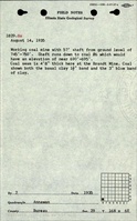
Sources of Data
| Microfilm, document 351377
|
11-9-1941
|
1:480
|
1:728
|
Not final
|
Annotated Bibliography (Data source - brief description of information)
| Coal Reports - Production, ownership, years of operation.
|
| Directory of Illinois Coal Mines (Bureau County) - Mine names, mine index, ownership, years of operation.
|
| Mine notes (Bureau County) - Mine type, shaft location, seam, depth, thickness.
|
| Microfilm map, document 351377, reel 03135, frame 415 - Shaft locations, mine outline, mining method.
|
| State archive, IL_1037 - Georegistration aid (used to scale microfilm image).
|
Mine Notes
Mine Images
Photographs
![[[:Brandt|Brandt]]](https://wikiimage.isgs.illinois.edu/ilmines/bureau/thumbnails/m2032_351377_geo_th.jpg)