Mine Index Number: 2400
| Company Name:
|
Lee Fisher
|
| Mine Name:
|
Fisher Mine
|
| Start Date:
|
1907
|
End Date:
|
1928
|
| Type of Mine:
|
Underground
|
| Total acres shown:
|
None
|
| Production Indicated Acres:
|
10
|
General Area of mining acres shown:
|
|
|
|
Shaft, Slope, Drift or Tipple Location(s)
| Type
|
County
|
Township-Range
|
Section
|
Part Section
|
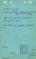
| Main shaft
|
Morgan
|
14N 10W
|
9
|
SW SW NW
|
Geology
Geological Problems Reported
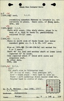
The shaft was deepened from 60 feet to a 3.0 feet thick seam at 95 feet deep in 1935. The deeper seam had many horsebacks, and the roof consisted of soft, flakey shale that would not stay up. Consequently, mining was abandoned shortly after opening up the lower seam.
Production
| Company
|
Mine Name
|
Date
|
Production (tons)
|
Production Notes
Coal Report production (if available)
Sources of Data
| ISGS field notes (E. T. Benson)
|
circa 1935
|
1:62500
|
1:62500
|
Secondary source
|
Annotated Bibliography (Data source - brief description of information)
| Coal Reports - Production, ownership, years of operation, mining method.
|
| Directory of Illinois Coal Mines (Morgan County) - Mine names, mine index, ownership, years of operation.
|
| Mine notes (Morgan County) - Mine type, shaft location, seam, depth, thickness.
|
| ISGS field notes (Morgan County) - Shaft location.
|
Mine Notes
Mine Images
Photographs