Mine Index Number: 2598
| Company Name:
|
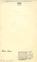
Price and Jones
|
| Mine Name:
|
Price and Jones Mine
|
| Start Date:
|
1887
|
End Date:
|
1898
|
| Type of Mine:
|
Underground
|
| Total acres shown:
|
10
|
| Production Indicated Acres:
|
17
|
General Area of mining acres shown:
|
|
|
|
Shaft, Slope, Drift or Tipple Location(s)
| Type
|
County
|
Township-Range
|
Section
|
Part Section
|
| Main shaft
|
La Salle
|
31N 3E
|
23
|
SE SE SW
|
Geology
Geological Problems Reported
A roll that was 16 feet long was present in one room, causing poor roof conditions.
Production
| Company
|
Mine Name
|
Date
|
Production (tons)
|
Production Notes
Coal Report production (if available)
Sources of Data
| Microfilm, mines09a.tif and mines09c.tif
|
Undated
|
Unknown
|
1:45248
|
Secondary source
|
Annotated Bibliography (Data source - brief description of information)
| Coal Reports - Production, ownership, years of operation, depth, thickness, geologic problems.
|
| Directory of Illinois Coal Mines (La Salle County) - Mine names, mine index, ownership, years of operation.
|
| Mine notes (La Salle County) - Mine type, shaft location, seam, depth, thickness.
|
| Microfilm map, Coal Section files, mines09a.tif & mine09c.tif - Shaft location, mine outline, mining method.
|
Mine Notes
Mine Images
Photographs