Mine Index Number: 2602
| Company Name:
|
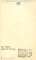
Joe Seroka
|
| Mine Name:
|
Seroka No. 1 Mine
|
| Start Date:
|
1914
|
End Date:
|
1920
|
| Type of Mine:
|
Underground
|
| Total acres shown:
|
5
|
| Acres after map date:
|
|
General Area of mining acres shown:
|
|
|
|
Shaft, Slope, Drift or Tipple Location(s)
| Type
|
County
|
Township-Range
|
Section
|
Part Section
|
| Main shaftAn un-mined area of the C., W. & V. (Third) No. 3 Mine (mine index 99) was mined by Seroka. Ventilation was probably through the old workings rather than an air shaft constructed by Seroka.
|
La Salle
|
31N 3E
|
23
|
SW NW SE
|
Geology
Geological Problems Reported
Production
| Company
|
Mine Name
|
Date
|
Production (tons)
|
Production Notes
Coal Report production (if available)
Sources of Data
| Microfilm, mines09a.tif and mines09c.tif
|
Undated
|
Unknown
|
1:45248
|
Secondary source
|
Annotated Bibliography (Data source - brief description of information)
| Coal Reports - Production, ownership, years of operation, depth, thickness, mining method.
|
| Directory of Illinois Coal Mines (La Salle County) - Mine names, mine index, ownership, years of operation.
|
| Mine notes (La Salle County) - Shaft location.
|
| Microfilm map, Coal Section files, mines09a.tif and mines09c.tif - Shaft location, mine outline, mining method.
|
Mine Notes
Mine Images
Photographs