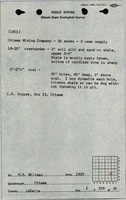
Mine Index Number: 2686
| Company Name:
|
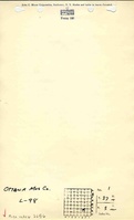
Ottawa Mining Company
|
| Mine Name:
|
Ottawa Mine
|
| Start Date:
|
1939
|
End Date:
|
1943
|
| Type of Mine:
|
Surface
|
| Total acres shown:
|
21
|
| Acres after map date:
|
|
General Area of mining acres shown:
|
|
|
|
Shaft, Slope, Drift or Tipple Location(s)
| Type
|
County
|
Township-Range
|
Section
|
Part Section
|
| Pit
|
La Salle
|
33N 3E
|
1
|
SE SE
|
Geology
| Colchester
|
18-20
|
|
|
2.0-2.5
|
Surface
|
Geological Problems Reported
Production
| Company
|
Mine Name
|
Date
|
Production (tons)
|
Production Notes
Coal Report production (if available)
Sources of Data
| Company, 4103.L32 i5.1-8
|
4-21-1942
|
1:4800
|
1:4800
|
Not final
|
| USGS topographic map
|
1994
|
1:24000
|
1:24000
|
Secondary source
|
Annotated Bibliography (Data source - brief description of information)
| Coal Reports - Production, ownership, years of operation.
|
| Directory of Illinois Coal Mines (La Salle County) - Mine names, mine index, ownership, years of operation.
|
| Mine notes (La Salle County) - Mine type, mine location, seam, depth, thickness.
|
| ISGS field notes (La Salle County) - Depth, thickness.
|
| Company (sketch) map, ISGS map library, 4103.L32 i5.1-8 - General mine location.
|
| Ottawa Quadrangle, USGS 7.5-minute topographic map, 1994 - Mine outline.
|
Mine Notes
Mine Images
Photographs