Mine Index Number: 2947
| Company Name:
|
John Mallergren, Sr.
|
| Mine Name:
|
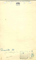
Riverside Mine
|
| Start Date:
|
1899
|
End Date:
|
1920
|
| Type of Mine:
|
Underground
|
| Total acres shown:
|
46
|
| Acres after map date:
|
|
General Area of mining acres shown:
|
|
|
|
Shaft, Slope, Drift or Tipple Location(s)
| Type
|
County
|
Township-Range
|
Section
|
Part Section
|
| Main shaft
|
Menard
|
18N 7W
|
13
|
NE SE NW
|
| Air shaft
|
Menard
|
18N 7W
|
13
|
SE NE NW
|
| Air / escape shaft
|
Menard
|
18N 7W
|
12
|
SW SW SE
|
| Air shaft (oldest)
|
Menard
|
18N 7W
|
13
|
NE SE NW
|
Geology
Geological Problems Reported
Production
| Company
|
Mine Name
|
Date
|
Production (tons)
|
| John Mallergren The spelling of Mallergren is uncertain. The listing in the Coal Reports was uncertain, and this name was spelled Mallegrahm, Mallegraham, Mallegram, millegram, Mallergran, Mellengrin, Mallergreen and Mallengren. Mellergren was the most frequently used version for John Sr. and John W. (John Jr.).
|
Riverside
|
1905-1912
|
27,204
|
|
|
| John Mallergren, Sr.
|
Riverside
|
1912-1920 The microfilm source map showed surveys done in 1915, 1921, 1925 and 1927. The mine was apparently active in 1925 and 1927, but the production is unknown. None of the unlocated mines with the Petersburg address fit the Riverside Mine.
|
45,579 The microfilm source map showed surveys done in 1915, 1921, 1925 and 1927. The mine was apparently active in 1925 and 1927, but the production is unknown. None of the unlocated mines with the Petersburg address fit the Riverside Mine.
|
|
|
Production Notes
Coal Report production (if available)
Sources of Data
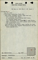
| Microfilm, document 352447
|
7-1911
|
1:1200
|
1:1200
|
Incomplete
|
| Microfilm, document 352221
|
12-13-1927
|
1:1200
|
1:1490
|
Incomplete
|
Annotated Bibliography (Data source - brief description of information)
| Coal Reports - Production, ownership, years of operation.
|
| Directory of Illinois Coal Mines (Menard County) - Mine names, mine index, ownership, years of operation.
|
| Mine notes (Menard County) - Mine type, shaft locations, seam, depth, thickness.
|
| Microfilm map, document 352447, reel 03139, frame 123 - Mine outline, shaft locations (hoist, oldest air).
|
| Microfilm map, document 352221, reel 03138, frame 279 - Mine outline, shaft locations (hoist, later air), mining method.
|
Mine Notes
Mine Images
Microfilm: 352221
Map Date: 12-13-1927
Coal Co.: John Mallergren, Sr.
Mine Name: Riverside Mine
Full Res Download
Microfilm: 352447
Map Date: 7-1911
Coal Co.: John Mallergren, Sr.
Mine Name: Riverside Mine
Full Res Download
Photographs