Mine Index Number: 3188
| Company Name:
|
Baldwin Coal Company
|
| Mine Name:
|
Nevin Mine
|
| Start Date:
|
1934
|
End Date:
|
1945
|
| Type of Mine:
|
Underground
|
| Total acres shown:
|
6
|
| Acres after map date:
|
3
|
General Area of mining acres shown:
|
|
|
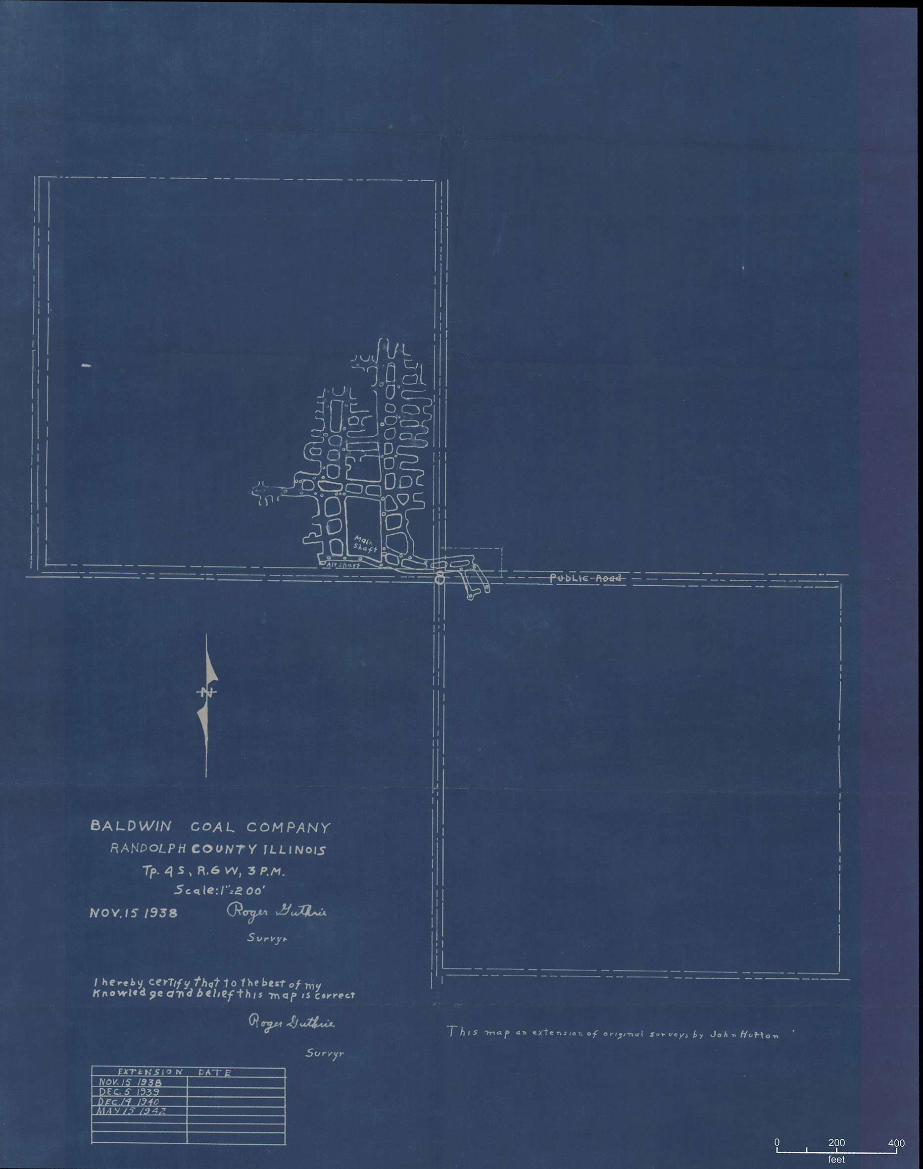
Not Shown On Map. This mine is not shown on the accompanying map because of later surface mining by River King Pit No. 6 Mine (mine index 934).
|
Shaft, Slope, Drift or Tipple Location(s)
| Type
|
County
|
Township-Range
|
Section
|
Part Section
|
| Main shaft
|
Randolph
|
4S 6W
|
8
|
SE SE NW
|
| Air shaft
|
Randolph
|
4S 6W
|
8
|
SE SE NW
|
Geology
Geological Problems Reported
Production
| Company
|
Mine Name
|
Date
|
Production (tons)
|
Production Notes
Coal Report production (if available)
Sources of Data
| Microfilm, document 353363
|
5-15-1942
|
1:2400
|
1:2658
|
Not final
|
Annotated Bibliography (Data source - brief description of information)
| Coal Reports - Production, ownership, years of operation.
|
| Directory of Illinois Coal Mines (Randolph County) - Mine names, mine index, ownership, years of operation.
|
| Mine notes (Randolph County) - Mine type, shaft location, seam, depth, thickness.
|
| Microfilm map, document 353363, reel 03142, frame 365 - Shaft locations, mine outline, mining method.
|
Mine Notes
Mine Images
 These files may not be true to scale and are not georgistered. These files may not be true to scale and are not georgistered.
|
Map Type:
|
State Archive
|
| Map ID:
|
IL_1026_01
|
| Company:
|
Baldwin Coal Company
|
| Mine Name:
|
|
| Caption:
|
|
| Map Date:
|
05-15-1942
|
| Map Status:
|
Not Final
|
| Image Credit:
|
|
| Note:
|
|
| More Info:
|
M3188 IL 1026 01
|
| Full Res Download:These files are true to scale and most are georegistered for gis software. These files may be a very large (>1GB) download!
|
https://wikiimage.isgs.illinois.edu/ilmines/randolph/m3188 IL 1026 01.zip
|
Photographs