Mine Index Number: 3271
| Company Name:
|
Blue Bird Coal Company
|
| Mine Name:
|
Blue Bird No. 2 Mine
|
| Start Date:
|
Unknown
|
End Date:
|
Unknown
|
| Type of Mine:
|
Surface
|
| Total acres shown:
|
45
|
| Acres after map date:
|
|
General Area of mining acres shown:
|
|
|
|
Shaft, Slope, Drift or Tipple Location(s)
| Type
|
County
|
Township-Range
|
Section
|
Part Section
|
Geology
Geological Problems Reported
Production
| Company
|
Mine Name
|
Date
|
Production (tons)
|
| Blue Bird Coal Company
|
Blue Bird No. 2No production was listed under this name in the annual Coal Reports. The production for this surface mine may have been reported under other surface mines of this company (No. 1 is mine index 610, No. 4 is mine index 3267, No. 5 is mine index 4206) or the coal may have been shipped from the tipple for the Blue Bird No. 6 (underground) Mine (mine index 3263).
|
|
|
|
|
Production Notes
Coal Report production (if available)
Sources of Data
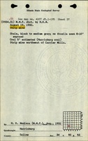
| ISGS field notes (H. R. Wanless)
|
8-19-1932
|
(text only)
|
1:24000The mine location was plotted on a 1:24000 USGS topographic map from the mine location description and digitized.
|
Secondary source
|
Annotated Bibliography (Data source - brief description of information)
| Directory of Illinois Coal Mines (Saline County) - Mine names, mine index, ownership, years of operation.
|
| Mine notes (Saline County) - Mine type, pit location, mining method.
|
| ISGS field notes (Saline County) - Pit location, seam, thickness, mining method.
|
Mine Notes
Mine Images
Photographs