Mine Index Number: 3491
| Company Name:
|
William J. Hippard Coal Company
|
| Mine Name:
|
Hippard No. 1 Mine
|
| Start Date:
|
1903
|
End Date:
|
1934
|
| Type of Mine:
|
Underground
|
| Total acres shown:
|
111
|
| Acres after map date:
|
37
|
General Area of mining acres shown:
|
|
|
|
Shaft, Slope, Drift or Tipple Location(s)
| Type
|
County
|
Township-Range
|
Section
|
Part Section
|
| Main shaft
|
St. Clair
|
1N 7W
|
35
|
NW NE SW
|
| Air shaft
|
St. Clair
|
1N 7W
|
35
|
NW NE SW
|
Geology
Geological Problems Reported
Production
| Company
|
Mine Name
|
Date
|
Production (tons)
|
|
|
|
|
|
| Total Production: 750,763
|
Production Notes
Coal Report production (if available)
Sources of Data
| Microfilm, document 351106
|
1-25-1923
|
1:2400
|
1:3972
|
Not final
|
Annotated Bibliography (Data source - brief description of information)
| Coal Reports - Production, ownership, years of operation.
|
| Directory of Illinois Coal Mines (St. Clair County) - Mine names, mine index, ownership, years of operation.
|
| Mine notes - Mine type, shaft location, seam, depth, thickness.
|
| Microfilm map, document 351106, reel 03134, frames 222, 223 - Shaft locations, mine outline, mining method.
|
Mine Notes
Mine Images
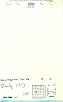
Microfilm: 351106
Map Date: 1-25-1923
Coal Co.: Liberty Coal and Mining Company
Mine Name: Liberty Mine
Full Res Download
Photographs