Mine Index Number: 3511
| Company Name:
|
Service Coal Company
|
| Mine Name:
|
Service Mine
|
| Start Date:
|
1895
|
End Date:
|
March 1945
|
| Type of Mine:
|
Underground
|
| Total acres shown:
|
348
|
| Acres after map date:
|
|
General Area of mining acres shown:
|
|
|
|
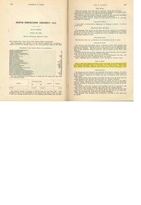
Shaft, Slope, Drift or Tipple Location(s)
| Type
|
County
|
Township-Range
|
Section
|
Part Section
|
| Main shaft
|
St. Clair
|
1N 8W
|
15
|
SE NW SW
|
| Air shaft
|
St. Clair
|
1N 8W
|
15
|
SE NW SW
|
Geology
| Herrin
|
110-150
|
|
|
6.0-6.5
|
MRP
|
Geological Problems Reported
Production
| Company
|
Mine Name
|
Date
|
Production (tons)
|
|
|
|
|
|
| Total Production: 2,328,229
|
Production Notes
Coal Report production (if available)
Sources of Data
| Microfilm, document 351040
|
3-20-1945
|
1:2400
|
1:4469
|
Final
|
| Microfilm, document 351141
|
8-12-1920
|
1:1200
|
1:2317
|
Secondary source Used only to designate the southern boundary.
|
Annotated Bibliography (Data source - brief description of information)
| Coal Reports - Production, ownership, years of operation.
|
| Directory of Illinois Coal Mines (St. Clair County) - Mine names, mine index, ownership, years of operation.
|
| Mine notes (St. Clair County) - Mine type, seam, depth, thickness.
|
| Microfilm map, document 351040, reel 03134, frames 128,129 - Shaft locations, mine outline, mining method.
|
| Microfilm map, document 351141, reel 03134, frames 279,280, map of Branch No. 2 Mine (mine index 3492) - Mine outline (southern boundary).
|
Mine Notes
Mine Images
Microfilm: 351141
Map Date: 8-12-1920
Coal Co.: White and Son
Mine Name: Branch No. 2
Full Res Download
Microfilm: 351040
Map Date: 3-20-1945
Coal Co.: Service Coal Company
Mine Name: Service
Full Res Download
Photographs