Mine Index Number: 3537
| Company Name:
|
|
| Mine Name:
|
New Athens Mine
|
| Start Date:
|
Before 1876
|
End Date:
|
Unknown
|
| Type of Mine:
|
Underground
|
| Total acres shown:
|
9
|
| Acres after map date:
|
|
General Area of mining acres shown:
|
|
|
|
Shaft, Slope, Drift or Tipple Location(s)
| Type
|
County
|
Township-Range
|
Section
|
Part Section
|
| Main shaft
|
St. Clair
|
2S 7W
|
34
|
NE SE SE
|
| Air shaft
|
St. Clair
|
2S 7W
|
34
|
NE SE SE
|
| Morganthal shaft The Morganthal shaft may have opened into a separate mine, unconnected to New Athens Coal Company. Included in old workings southwest of Pep Mine No. 2 (mine index 795).
|
St. Clair
|
2S 7W
|
35
|
SE NW SW
|
Geology
Geological Problems Reported
Production
| Company
|
Mine Name
|
Date
|
Production (tons)
|
| New Athens Coal Mine
|
New Athens
|
1876 Production unknown for mines operating prior to 1881. See “Mines Whose Locations Are Not Known, New Athens East Quadrangle” at the back of this report. This mine may be the same as the New Athens Coal Company operating in 1888.
|
|
|
|
Production Notes
Coal Report production (if available)
Sources of Data
| Microfilm, document 351168
|
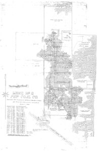
12-30-1953 The source map states the workings for the New Athens Mine were dated 8-4-1876.
|
1:2400
|
1:3972
|
Secondary source
|
Annotated Bibliography (Data source - brief description of information)
| Directory of Illinois Coal Mines (St. Clair County) - Mine location.
|
| Microfilm map, document 351168, reel 03134, frame 314, map of Pep No. 2 Mine (mine index 0795) - Shaft locations, mine outline, mining method.
|
Mine Notes
Mine Images
Microfilm: 351168
Map Date: 12-30-1953
Coal Co.: Pep Coal Company
Mine Name: Pep No. 2 Mine
Full Res Download
Photographs

