Mine Index Number: 4102
| Company Name:
|
Unknown
|
| Mine Name:
|
Unknown Mine
|
| Start Date:
|
Before 1925
|
End Date:
|
Unknown
|
| Type of Mine:
|
Surface
|
| Total acres shown:
|
None
|
| Acres after map date:
|
|
General Area of mining acres shown:
|
|
|
|
Shaft, Slope, Drift or Tipple Location(s)
| Type
|
County
|
Township-Range
|
Section
|
Part Section
|
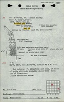
| Pit
|
Williamson
|
9S 4E
|
26
|
NE SE NW
|
Geology
Geological Problems Reported
Production
| Company
|
Mine Name
|
Date
|
Production (tons)
|
Production Notes
Coal Report production (if available)
Sources of Data
| ISGS field notes (G. H. Cady)
|
7-6-1925
|
1:62500
|
1:62500
|
Secondary source
|
| Mine notes
|
Undated
|
1:62500
|
1:62500
|
Secondary source
|
Annotated Bibliography (Data source - brief description of information)
| ISGS field notes (Williamson County) - Mine location, mine type, seam, thickness.
|
| Mine notes (Williamson County) - Mine location, mine type, seam, thickness.
|
Mine Notes
Mine Images
Photographs