Mine Index Number: 4162
| Company Name:
|
Harris and Hanks
|
| Mine Name:
|
Harris and Hanks Mine
|
| Start Date:
|
1932
|
End Date:
|
1936
|
| Type of Mine:
|
Underground
|
| Total acres shown:
|
None
|
| Production Indicated Acres:
|
Less than 2
|
General Area of mining acres shown:
|
|
|
Not Shown On Map. This mine is not shown on the accompanying map because of later surface mining by Amax Coal Company (mine index 0702).
|
Shaft, Slope, Drift or Tipple Location(s)
| Type
|
County
|
Township-Range
|
Section
|
Part Section
|
| Main shaft
|
Williamson
|
9S 4E
|
35
|
SE SE SE This location is very uncertain. The mine notes indicated the mine was in T10S, but a flood plain exists at that location, which makes that location very unlikely. This mine is not shown on the accompanying map because of later surface mining by Amax Coal Company (mine index 702).
|
Geology
Geological Problems Reported
Production
| Company
|
Mine Name
|
Date
|
Production (tons)
|
Production Notes
Coal Report production (if available)
Sources of Data
| Mine notes
|
Undated
|
1:62500
|
1:62500
|
Secondary source
|
Annotated Bibliography (Data source - brief description of information)
| Coal Reports - Production, ownership, years of operation.
|
| Directory of Illinois Coal Mines (Williamson County) - Mine names, mine index, ownership, years of operation.
|
| Mine notes (Williamson County) - Mine type, shaft location.
|
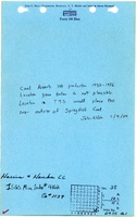
Mine Notes
Mine Images
Photographs