Mine Index Number: 4269
| Company Name:
|
Unknown
|
| Mine Name:
|
Unknown Mine
|
| Start Date:
|
Before 1874
|
End Date:
|
1934
|
| Type of Mine:
|
Underground
|
| Total acres shown:
|
None
|
| Acres after map date:
|
|
General Area of mining acres shown:
|
|
|
|
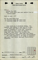
Shaft, Slope, Drift or Tipple Location(s)
| Type
|
County
|
Township-Range
|
Section
|
Part Section
|
| Shaft
|
St. Clair
|
2N 8W
|
17
|
W 1/2 NW NE
|
| Shaft
|
St. Clair
|
2N 8W
|
17
|
SE NE NW
|
Geology
Geological Problems Reported
Production
| Company
|
Mine Name
|
Date
|
Production (tons)
|
Production Notes
Coal Report production (if available)
Sources of Data
| Federal Land Bank Report
|
5-1934
|
1:124320
|
1:124320
|
Secondary source
|
| Atlas of St. Clair County
|
1874
|
1:36205
|
1:36205
|
Secondary source
|
Annotated Bibliography (Data source - brief description of information)
| Federal Land Bank Report (St. Clair County) - Shaft location (eastern), general area of mining.
|
| Atlas of St. Clair County, Illinois, 1874, Warner & Beers, Chicago, Illinois - Shaft location (western).
|
Mine Notes
Mine Images
Photographs