Mine Index Number: 4779
| Company Name:
|
|
| Mine Name:
|
|
| Start Date:
|
Unknown
|
End Date:
|
Unknown
|
| Type of Mine:
|
Underground
|
| Total acres shown:
|
|
| Acres after map date:
|
|
General Area of mining acres shown:
|
|
|
|
Shaft, Slope, Drift or Tipple Location(s)
| Type
|
County
|
Township-Range
|
Section
|
Part Section
|
| Shaft
|
Christian
|
12N 3W
|
27
|
NW SW SE
|
Geology
Geological Problems Reported
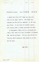
No coal was found, and no actual mining took place.
Production
| Company
|
Mine Name
|
Date
|
Production (tons)
|
Production Notes
Coal Report production (if available)
Sources of Data
| Coal Section files (Nokomis Quadrangle)
|
Undated
|
1:62500
|
1:62500
|
Secondary source
|
Annotated Bibliography (Data source - brief description of information)
| Mine notes (Christian County) - Mine type, mine location, seam, geologic problems.
|
| Coal Section files, undated work map on USGS topographic map, Nokomis (15-minute) Quadrangle - Mine location.
|
Mine Notes
Mine Images
Photographs