Danville NW Quadrangle
Mining in the Danville NW Quadrangle
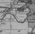
The Danville Coal was the only seam mined in the Danville Northwest Quadrangle. This location is at the edge of the Illinois Basin and the coal was minable with both surface and underground methods.
The Danville Coal ranged from 4.75 to over 6 feet thick (thinner where eroded). The depth ranged from very little cover to over 100 feet. The Danville Coal had some geologic problems for mining. Generally, it was closer to the surface, and sometimes water came into the mine. This was aggravated in some circumstances due to channel systems that were contemporaneous with deposition of the upper part of the coal and the roof shales. The channels sometimes cut down into the coal. Horsebacks and rolls were common in the area, but little information is available for the mines in this quadrangle.
Mining was an important part of the history of Danville since the coal was shallow. The Hungry Hollow area was the location of numerous small mines. Most of the early mines were quite small, the more extensive mines not beginning until around 1860. Michael Kelly began surface mining in 1868 along the North Fork but soon moved to Grape Creek and established several mines in that area. The earliest documented underground mine in the Danville Northwest Quadrangle is the Old Diamond Mine, which began operation about 1870.
Map and Directory PDF Download
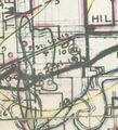
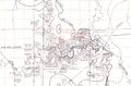
Coal Mines In Illinois Danville NW Quadrangle
Mines that Appear on the Danville NW Quadrangle
Unlocated Mines
Vermilion County
Pages in category "Danville NW Quadrangle"
The following 200 pages are in this category, out of 366 total.
(previous page) (next page)1
- 1830001
- 1830006
- 1830007
- 1830008
- 1830009
- 1830010
- 1830014
- 1830016a
- 1830016b
- 1830016c
- 1830017
- 1830018
- 1830019
- 1830022
- 1830023
- 1830025
- 1830026a
- 1830029a
- 1830032
- 1830033
- 1830034
- 1830036
- 1830038
- 1830039a
- 1830040
- 1830041a
- 1830042a
- 1830042b
- 1830042c
- 1830043a
- 1830043b
- 1830044
- 1830046
- 1830047a
- 1830048
- 1830052
- 1830053
- 1830054
- 1830055
- 1830056
- 1830061
- 1830062
- 1830063
- 1830066
- 1830069
- 1830070
- 1830074
- 1830080
- 1830081
- 1830082
- 1830083
- 1830084
- 1830085
- 1830086
- 1830089
- 1830094
- 1830096
- 1830103
- 1830104
- 1830105
- 1830106
- 1830107
- 1830108
- 1830109
- 1830110
- 1830112
- 1830113
- 1830122
- 1830123
- 1830124
- 1830126
- 1830126a
- 1830128
- 1830129
- 1830130
- 1830136
- 1830137
- 1830151
- 1830152
- 1830153
- 1830155
- 1830156
- 1830157
- 1830159
- 1830160
- 1830164a
- 1830165c
- 1830166a
- 1830166b
- 1830168
- 1830169
- 1830173a
- 1830173b
- 1830174
- 1830175
- 1830177
- 1830179
- 1830180
- 1830181
- 1830188
- 1830190
- 1830191
- 1830192
- 1830195
- 1830196
- 1830197
- 1830198
- 1830203
- 1830209
- 1830214
- 1830215
- 1830216a
- 1830216b
- 1830216c
- 1830217a
- 1830217b
- 1830221a
- 1830221b
- 1830223
- 1830224
- 1830228
- 1830231
- 1830233
- 1830234
- 1830238
- 1830239
- 1830240
- 1830241
- 1830243
- 1830244
- 1830246
- 1830247
- 1830249
- 1830250
- 1830252
- 1830267
- 1830269
- 1830271
- 1830272
- 1830273
- 1830274
- 1830275
- 1830280
- 1830281
- 1830282
- 1830289
- 1830297
- 1830300
- 1830301
- 1830304
- 1830305
- 1830306
- 1830307
- 1830308
- 1830309
- 1830310
- 1830311
- 1830312
- 1830313
- 1830314
- 1830316
- 1830317
- 1830318a
- 1830318b
- 1830319
- 1830320
- 1830321
- 1830322
- 1830324
- 1830325
- 1830326
- 1830328
- 1830329
- 1830330
- 1830331a
- 1830334
- 1830335
- 1830336
- 1830337
- 1830339
- 1830340
- 1830341
- 1830342
- 1830343
- 1830344
- 1830346
- 1830346b
- 1830347
- 1830349
- 1830351
- 1830352
- 1830353
- 1830354
- 1830359
- 1830363
- 1830366
- 1830367
Media in category "Danville NW Quadrangle"
The following 9 files are in this category, out of 9 total.
 M0094 quade.jpg 402 × 441; 61 KB
 M0400 no7thick.jpg 3,390 × 2,233; 1.08 MB
 M0673 minenotes.pdf 739 × 1,193, 43 pages; 11.23 MB
 M0673.jpg 3,390 × 1,982; 1.26 MB
 M3728 minenotes.pdf 739 × 1,193, 9 pages; 2.68 MB
 M6776.jpg 1,918 × 3,390; 682 KB
 M6788.jpg 1,327 × 1,310; 253 KB
 M6851 minenotes.pdf 739 × 1,193, 5 pages; 1.41 MB
 M6851mrg.jpg 3,390 × 3,094; 341 KB


