Macon West Quadrangle
Mining in the Macon West Quadrangle
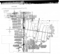
The Moweaqua Mine (mine index 217) operated from 1892 to 1935. The Springfield Coal was mined, at over 600 feet deep. On December 24, 1932, the barometric pressure dropped. The drop was sufficient to drive methane gas out of the old workings. Seals had been weakened imperceptibly by normal degradation of the roof in abandoned rooms, and nodules that may have fallen against the seals. Between the time when the certified Mine Examiner checked the mine and when the miners arrived at the workplace, the barometric low passed through, driving methane gas from the abandoned workings into the active portion of the mine. Some gas had traveled along the entries, with a great pocket collected further back. When the men stood up, with their open-flame lamps, the gas exploded and acted as a fuse leading the flame back to the large pocket of methane, resulting in a terrible explosion. Those that survived the explosion were unable to survive the bad air that resulted. A large roof fall, over 800 feet long in one direction and 1500 feet long in another direction, blocked access and escape from the carbon monoxide. The roof fall may have prevented the further explosion of coal dust by dispersing rock dust from the shale roof, according to the state mine inspectors who investigated the explosion and directed rescue efforts. The disaster killed 54 men.
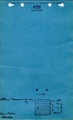
The Blue Mound Mine No. 1 Mine (mine index 280) operated from 1904 to 1913. The shaft was about 500 feet deep. No map has been found for the mine.
Map and Directory PDF Download
Coal Mines In Illinois Macon West Quadrangle
Mines that Appear on the Macon West Quadrangle
Unlocated Mines
Macon County
Shelby County
Christian County
Media in category "Macon West Quadrangle"
The following 4 files are in this category, out of 4 total.
 M0217.jpg 3,500 × 3,124; 2.52 MB
 M0280 coalreport1903 p231.pdf 743 × 1,172; 303 KB
 M0280 coalreport1904 p261.pdf 743 × 1,175; 379 KB
 M0280 minenotes.pdf 731 × 1,202, 4 pages; 1.11 MB
