Mine Index Number: 0366
| Company Name:
|
Orient Number Two Coal Company
|
| Mine Name:
|
Orient No. 2 Mine
|
| Start Date:
|
1922
|
End Date:
|
November 1960
|
| Type of Mine:
|
Underground
|
| Total acres shown:
|
9,638
|
| Acres after map date:
|
46
|
General Area of mining acres shown:
|
|
|
|
Shaft, Slope, Drift or Tipple Location(s)
| Type
|
County
|
Township-Range
|
Section
|
Part Section
|
| Main shaft
|
Franklin
|
7S 2E
|
13
|
NW SE SW
|
| Auxiliary shaft
|
Franklin
|
7S 2E
|
13
|
NE SE SW
|
| Shaft No. 3 (air)
|
Franklin
|
7S 2E
|
1
|
SE NE NW
|
| Shaft No. 4 (motor)
|
Franklin
|
6S 2E
|
36
|
NE NE SW
|
Geology
| Herrin
|
480-500
|
8.0
|
12.5
|
9.0
|
HER
|
Geological Problems Reported
An explosion in 1951 resulted in 119 men killed, ranking second only to the Cherry Mine fire (Bureau County, 1909) in number of deaths. The mine had been classified as gassy, and had additional safety procedures (rock dusting to alleviate combustible coal dust in the mine, certified examiners monitoring the mine prior to each shift, etc.) An exhaustive investigation of the cause of ignition was narrowed down to two possibilities: an electrical arc from the operation of a motor or personnel smoking underground. The methane gas had apparently migrated from abandoned workings. The roof was at least 40 feet of shale, and generally up to 19 inches of top coal was left to support this roof. Some calcite appeared as fracture filler, and some thin pyrite stringers were present in the top coal. Some small slips were present, but did not seriously affect mining. The northward dip of the bed and the presence of a few rolls required some grading to be performed. The floor consisted of 4 to 18 inches of underclay that heaved “readily but not far”. The microfilm source map shows generally north-trending faults along the west side of the mine, part of the Rend Lake Fault System. In some cases, mining was not badly impacted, but in other areas, entries and rooms were truncated due to faulting.
Production
| Company
|
Mine Name
|
Date
|
Production (tons)
|
|
|
|
|
|
| Total Production: 61,107,440
|
Production Notes
Coal Report production (if available)
Sources of Data
| Microfilm, document 351453
|
7-1-1960
|
1:2400
|
1:5296
|
Not final
|
| Company, 4103.F7 i5.1-63
|
1-1-1960
|
1:12000
|
1:12000
|
Not final
|
Annotated Bibliography (Data source - brief description of information)
| Coal Reports - Production, ownership, years of operation, depth, geologic problems.
|
| Directory of Illinois Coal Mines (Franklin County) - Mine names, mine index, ownership, years of operation.
|
| Mine notes (Franklin County) - Mine type, shaft location, seam, depth, thickness, geologic problems.
|
| Microfilm map, document 351453, reel 03136, frames 160-171 - Shaft locations, mine outline, mining method.
|
| Company map, ISGS map library, 4103.F7 i5.1-63 - Shaft locations.
|
Mine Notes
Mine Images
![[[:Orient No. 2|Orient No. 2]]](https://go.illinois.edu/ILMImages/franklin/thumbnails/m0366_th.jpg) These files may not be true to scale and are not georgistered. These files may not be true to scale and are not georgistered.
|
Map Type:
|
Microfilm
|
| Map ID:
|
351453
|
| Company:
|
Orient Number Two Coal Company
|
| Mine Name:
|
Orient No. 2
|
| Caption:
|
|
| Map Date:
|
7-1-1960
|
| Map Status:
|
Not final
|
| Image Credit:
|
|
| Note:
|
|
| More Info:
|
M0366
|
| Full Res Download:These files are true to scale and most are georegistered for gis software. These files may be a very large (>1GB) download!
|
https://wikiimage.isgs.illinois.edu/ilmines/franklin/m0366.zip
|
Photographs
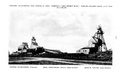
Caption: Orient No. 2 Mine Main Shaft, Making Pit for Erection of Sinking Shoe
Credit: Ledvina Collection
Date: April 30, 1921
Caption: Orient No. 2 Mine. Starting Excavation at Hoisting Shaft preparatory to the assembly of Sinking Shoe. Depth 6 feet.
Credit: Ledvina Collection
Date: April 29, 1921
Caption: Orient Mine No. 2. Excavation for Main Tipple
Credit: Ledvina Collection
Date: December 15, 1922
Caption: New Orient Mine. "Ohio Brass" coupler
Credit: Ledvina Collection
Date: October 2, 1923
Caption: Orient Mine No. 2. Composite mine car showing Ohio Brass Co. coupler. Fleming Trucks and Wheels.
Credit: Ledvina Collection
Date: October 14, 1922
Caption: Orient Mine No. 2. Steel and composite mine car.
Credit: Ledvina Collection
Date: November 3, 1922
Caption: Orient Mine No. 2. A. & G. mine car coupler
Credit: Ledvina Collection
Date: November 3, 1922
Caption: Joy Loading Machine
Credit: Ledvina Collection
Caption: Picking Tables
Credit: Ledvina Collection
Date: 1935
Caption: Prep Plant
Credit: Ledvina Collection
Caption: Orient 2, Lab
Credit: Ledvina Collection
Credit: Ledvina Collection
Credit: Ledvina Collection
Caption: Small hoist house
Credit: Ledvina Collection
Credit: Ledvina Collection