0062: Difference between revisions
Alan.Myers (talk | contribs) No edit summary |
No edit summary |
||
| Line 1: | Line 1: | ||
{{Sidebar Info Query}} | {{Sidebar Info Query}} | ||
{{Header | {{Header | ||
|checked=1st Entry | |||
|unlocated=No | |unlocated=No | ||
|shown_on_map=Yes | |shown_on_map=Yes | ||
| Line 11: | Line 12: | ||
|quad1=Herrin | |quad1=Herrin | ||
|year-start=1900 | |year-start=1900 | ||
|year-end=1931 | |year-end=April 1931 | ||
|Latitude=37.8133187496942 | |Latitude=37.8133187496942 | ||
|Longitude=-89.0359490508037 | |Longitude=-89.0359490508037 | ||
| Line 110: | Line 111: | ||
{{Query-image}} | {{Query-image}} | ||
===Photographs=== | |||
{{Photo Query}} | |||
==Additional Notes== | |||
{{Editwithform}} | |||
{{Editwithform}} | {{Editwithform}} | ||
Revision as of 19:58, December 6, 2021
Mine Index Number: 0062
| Company Name: | Chicago, Wilmington and Franklin Mining Company | ||
|---|---|---|---|
| Mine Name: | A Mine | ||
| Start Date: | 1900 | End Date: | April 1931 |
| Type of Mine: | Underground | ||
| Total acres shown: | 1,890 | ||
| Acres after map date: | General Area of mining acres shown: | ||
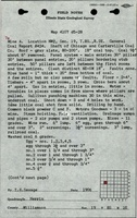
Shaft, Slope, Drift or Tipple Location(s)
| Type | County | Township-Range | Section | Part Section |
|---|
| Main shaft (9.5 x 17 ft) | Williamson | 8S 2E | 19 | SE SW NW |
| Air shaft (9 x 15 ft) | Williamson | 8S 2E | 19 | NE SW NW |
Geology
| Thickness (ft) | |||||
|---|---|---|---|---|---|
| Seam | Depth (ft) | Min | Max | Ave | Mining Method |
| Herrin | 171-180 | 9.0-9.5 | RPP |
Geological Problems Reported
An explosion of fire damp killed two men in 1906, and a gas explosion killed eight men in 1909. One large slip in the roof caused a roof fall of coal and shale that killed a miner in 1909. The mine map showed areas in Sections 12 and 13 of T8S-R2E that had bad top, bad conditions, and dirty coal. The shale did not make a good roof so that 18 to 24 inches (average 18 inches) of top coal was left to support the roof. The coal contained some pyrite streaks. Some water problems were noted, and said to come from the surface rather than seeping into the mine through the roof. The underclay floor was 2 to 5 feet thick. Some squeezes resulted in surface subsidence.
Production
| Company | Mine Name | Date | Production (tons) |
| Chicago-Carterville Coal Company | Chicago-Carterville No. 1 | 1900-1905 | 1,311,971 |
| Chicago-Carterville Coal Company | A | 1905-1917 | 4,566,197 |
| Chicago, Wilmington and Franklin Mining Company | A | 1917-1931 | 7,255,128 |
Production Notes
Coal Report production (if available)
Sources of Data
| Source Map | Map Date | Original Scale | Digitized Scale | Map Type |
| Microfilm, document 353299 | 4-18-1931 | 1:2400 | 1:4303 | Final |
| Microfilm, document 353288 | 7-1-1930 | 1:2400 | 1:4966 | Not Final |
Annotated Bibliography (Data source - brief description of information)
| Coal Reports - Production, ownership, years of operation, depth, thickness, geologic problems. |
| Directory of Illinois Coal Mines (Williamson County) - Mine names, mine index, ownership, years of operation. |
| ENR Document 85/01 - Mining method. |
| Mine notes (Williamson County) - Mine type, shaft location, seam, depth, thickness, geologic problems. |
| Microfilm map, document 353299, reel 03142, frames 258-261 - Shaft locations, mine outline, mining method, geologic problems. |
| Microfilm map, document 353288, reel 03142, frame 234 - Mine outline (faded portions in W ½ 13-T8S-R2E). 10 |
Mine Notes
Mine Images
![[[:A|A]]](https://wikiimage.isgs.illinois.edu/ilmines/williamson/thumbnails/m0062b_th.jpg)
![[[:A|A]]](https://wikiimage.isgs.illinois.edu/ilmines/williamson/thumbnails/m0062_th.jpg)
Photographs
Additional Notes