0166: Difference between revisions
No edit summary |
No edit summary |
||
| Line 1: | Line 1: | ||
{{Sidebar Info Query}} | {{Sidebar Info Query}} | ||
{{Header | {{Header | ||
|checked= | |checked=Checked OK | ||
|unlocated=No | |unlocated=No | ||
|shown_on_map=Yes | |shown_on_map=Yes | ||
|reason_nsm=A small portion of the western side of this mine was later surface-mined by the S Mine (mine index 1027). | |||
|Mine-index=0166 | |Mine-index=0166 | ||
|Coal_co=Peabody Coal Company | |Coal_co=Peabody Coal Company | ||
|Mine Name Header=Peabody No. 16 Mine | |Mine Name Header=Peabody No. 16 Mine | ||
|mine_type=Underground | |mine_type=Underground | ||
|mined-out-area=255 | |mined-out-area=255 | ||
|county1=Williamson | |county1=Williamson | ||
|quad1=Herrin | |quad1=Herrin | ||
| Line 79: | Line 80: | ||
{{Source map header}} | {{Source map header}} | ||
{{Source Map | {{Source Map | ||
|Source Map=Company | |Source Map=Company, 4102.W52 i5.1-135 | ||
|Map Date=9-1-1927 | |Map Date=9-1-1927 | ||
|Original Scale=1:2400 | |Original Scale=1:2400 | ||
| Line 91: | Line 92: | ||
{{Annotated bibliography | {{Annotated bibliography | ||
|bibliography=Directory of Illinois Coal Mines (Williamson County) - Mine names, mine index, ownership, years of operation. | |bibliography=Directory of Illinois Coal Mines (Williamson County) - Mine names, mine index, ownership, years of operation. | ||
}} | }} | ||
{{Annotated bibliography | {{Annotated bibliography | ||
| Line 110: | Line 108: | ||
{{Photo Query}} | {{Photo Query}} | ||
{{Editwithform}} | {{Editwithform}} | ||
{{#set: Mine-Name=Carterville No. 1}} | {{#set: Mine-Name=Carterville No. 1}} | ||
Revision as of 17:33, December 10, 2021
Mine Index Number: 0166
| Company Name: | Peabody Coal Company | ||
|---|---|---|---|
| Mine Name: | Peabody No. 16 Mine | ||
| Start Date: | 1900 | End Date: | January 1927 |
| Type of Mine: | Underground | ||
| Total acres shown: | 255 | ||
| Acres after map date: | General Area of mining acres shown: | ||
|
A small portion of the western side of this mine was later surface-mined by the S Mine (mine index 1027). | |||
Shaft, Slope, Drift or Tipple Location(s)
| Type | County | Township-Range | Section | Part Section |
|---|
| Main shaft This mine is connected underground to Carterville No. 3 Mine (mine index 812). | Williamson | 8S 1E | 33 | NW NE NW |
| Air shaft | Williamson | 8S 1E | 33 | NE NE NW |
Geology
| Thickness (ft) | |||||
|---|---|---|---|---|---|
| Seam | Depth (ft) | Min | Max | Ave | Mining Method |
| Herrin | 74-100 | 8.0-9.5 | MRP |
Geological Problems Reported
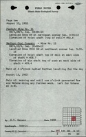
Much surface water entered the mine through slips in the overlying shale, even coming in as a constant flow in the northern part of the mine. In a few places in the northern part of the mine, the roof consisted of 6 to 18 inches of fissile shale that would fall when the top coal came down, and the fall would propagate upward several feet. Whenever possible, 20 to 24 inches of top coal was left to support the roof. The floor was a soft green shale that heaved when the entries were too wide. Squeezes were reported in the western part of the mine.
Production
| Company | Mine Name | Date | Production (tons) |
| Independent Coal Company | Independent | 1900-1902 | 150,000 |
| Carterville and Big Muddy Coal Company | John, Carterville No. 1 | 1902-1922 | 2,096,322 |
| Peabody Coal Company | Peabody No. 16 | 1922-1927 Idle 1924 | 92,498 |
Production Notes
Coal Report production (if available)
Sources of Data
| Source Map | Map Date | Original Scale | Digitized Scale | Map Type |
| Company, 4102.W52 i5.1-135 | 9-1-1927 | 1:2400 | 1:2400 | Final |
Annotated Bibliography (Data source - brief description of information)
| Coal Reports - Production, ownership, years of operation, depth, thickness. |
| Directory of Illinois Coal Mines (Williamson County) - Mine names, mine index, ownership, years of operation. |
| Mine notes (Williamson County) - Mine type, shaft location, seam, geologic problems. |
| Company map, ISGS map library, 4102.W52 i5.1-135 - Shaft locations, mine outline, mining method. |
Mine Notes
Mine Images
![[[:Peabody No. 16|Peabody No. 16]]](https://wikiimage.isgs.illinois.edu/ilmines/williamson/thumbnails/m0166_th.jpg)
Photographs