0173: Difference between revisions
No edit summary |
No edit summary |
||
| Line 1: | Line 1: | ||
{{Sidebar Info Query}} | {{Sidebar Info Query}} | ||
{{Header | {{Header | ||
|checked= | |checked=Checked OK | ||
|unlocated=No | |unlocated=No | ||
|shown_on_map=Yes | |shown_on_map=Yes | ||
| Line 11: | Line 11: | ||
|county1=Williamson | |county1=Williamson | ||
|quad1=Johnston City | |quad1=Johnston City | ||
|quad2=Marion | |||
|year-start=1917 | |year-start=1917 | ||
|year-end=March 1924 | |year-end=March 1924 | ||
| Line 93: | Line 94: | ||
{{Photo Query}} | {{Photo Query}} | ||
{{Editwithform}} | {{Editwithform}} | ||
{{Editwithform}} | {{Editwithform}} | ||
Revision as of 17:51, December 10, 2021
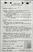
Mine Index Number: 0173
| Company Name: | Henderson and Wallace Coal Company | ||
|---|---|---|---|
| Mine Name: | Henderson and Wallace No. 1 Mine | ||
| Start Date: | 1917 | End Date: | March 1924 |
| Type of Mine: | Underground | ||
| Total acres shown: | 320 This includes the area for mine index 4061, Old Bruce Mine (formerly Henderson & Wallace No. 2 Mine). | ||
| Acres after map date: | General Area of mining acres shown: | ||
Shaft, Slope, Drift or Tipple Location(s)
| Type | County | Township-Range | Section | Part Section |
|---|
| Main shaft | Williamson | 9S 3E | 8 | SW SW NE |
Geology
| Thickness (ft) | |||||
|---|---|---|---|---|---|
| Seam | Depth (ft) | Min | Max | Ave | Mining Method |
| Herrin | 65-67 | 5.0 | 8.3 Maximum thickness not specifically stated, but samples were taken from areas where the total thickness ranged from 7.0 to 8.3 feet. | 6.5 | RP |
Geological Problems Reported
The northern part of the mine had good limestone roof, but the floor was 4 to 5 feet of claystone that heaved only a little. Elsewhere, the roof was gray shale and tended to fall badly when it was thick. Even this poor roof thinned to the south, nearing the subcrop, and prevented further mine expansion southward. Water entered the mine from surface gravels. The center part of the seam contained many shaly partings. Some pyrite and calcite or gypsum was present in vertical streaks. Some small local faults occurred in the coal. A roll forced the coal down 3 feet. In one location, boulder-sized concretions made mining impossible. The concretions were finely crystalline calcite and ranged from 1 to 3 feet in diameter.
Production
| Company | Mine Name | Date | Production (tons) |
| Henderson and Wallace Coal Company | Henderson and Wallace No. 1 | 1917-1924 | 1,102,890 |
Production Notes
Coal Report production (if available)
Sources of Data
| Source Map | Map Date | Original Scale | Digitized Scale | Map Type |
| ISGS map library, 4103.W52 i5.1-189 | 8-11-1934 | 1:63360 | 1:63360 | Secondary source |
Annotated Bibliography (Data source - brief description of information)
| Coal Reports - Production, ownership, years of operation, mining method. |
| Directory of Illinois Coal Mines (Williamson County) - Mine names, mine index, ownership, years of operation. |
| Mine notes (Williamson County) - Mine type, shaft location, seam, depth, thickness, geologic problems. |
| Composite map from J. C. Quade field notes, ISGS map library, 4103.W52 i5.1-189 - Shaft location, mine outline. |
| Catalog of Coal Mines in Williamson County, W. John Nelson, 2003 - Geologic problems. |
Mine Notes
Mine Images

Photographs