0943: Difference between revisions
Alan.Myers (talk | contribs) No edit summary |
No edit summary |
||
| Line 1: | Line 1: | ||
{{Sidebar Info Query}} | {{Sidebar Info Query}} | ||
{{Header | {{Header | ||
|checked=Checked OK | |||
|unlocated=No | |unlocated=No | ||
|shown_on_map=Yes | |shown_on_map=Yes | ||
| Line 11: | Line 12: | ||
|quad1=Herrin | |quad1=Herrin | ||
|year-start=1970 | |year-start=1970 | ||
|year-end=1980 | |year-end=February 1980 | ||
|Latitude=37.7794122049341 | |Latitude=37.7794122049341 | ||
|Longitude=-89.0083033663406 | |Longitude=-89.0083033663406 | ||
| Line 89: | Line 90: | ||
{{Query-image}} | {{Query-image}} | ||
===Photographs=== | |||
{{Photo Query}} | |||
==Additional Notes== | |||
{{Editwithform}} | |||
{{Editwithform}} | {{Editwithform}} | ||
Revision as of 17:44, December 13, 2021
Mine Index Number: 0943
| Company Name: | Cold Water Coal Company | ||
|---|---|---|---|
| Mine Name: | Cold Water No. 2 Mine | ||
| Start Date: | 1970 | End Date: | February 1980 |
| Type of Mine: | Surface | ||
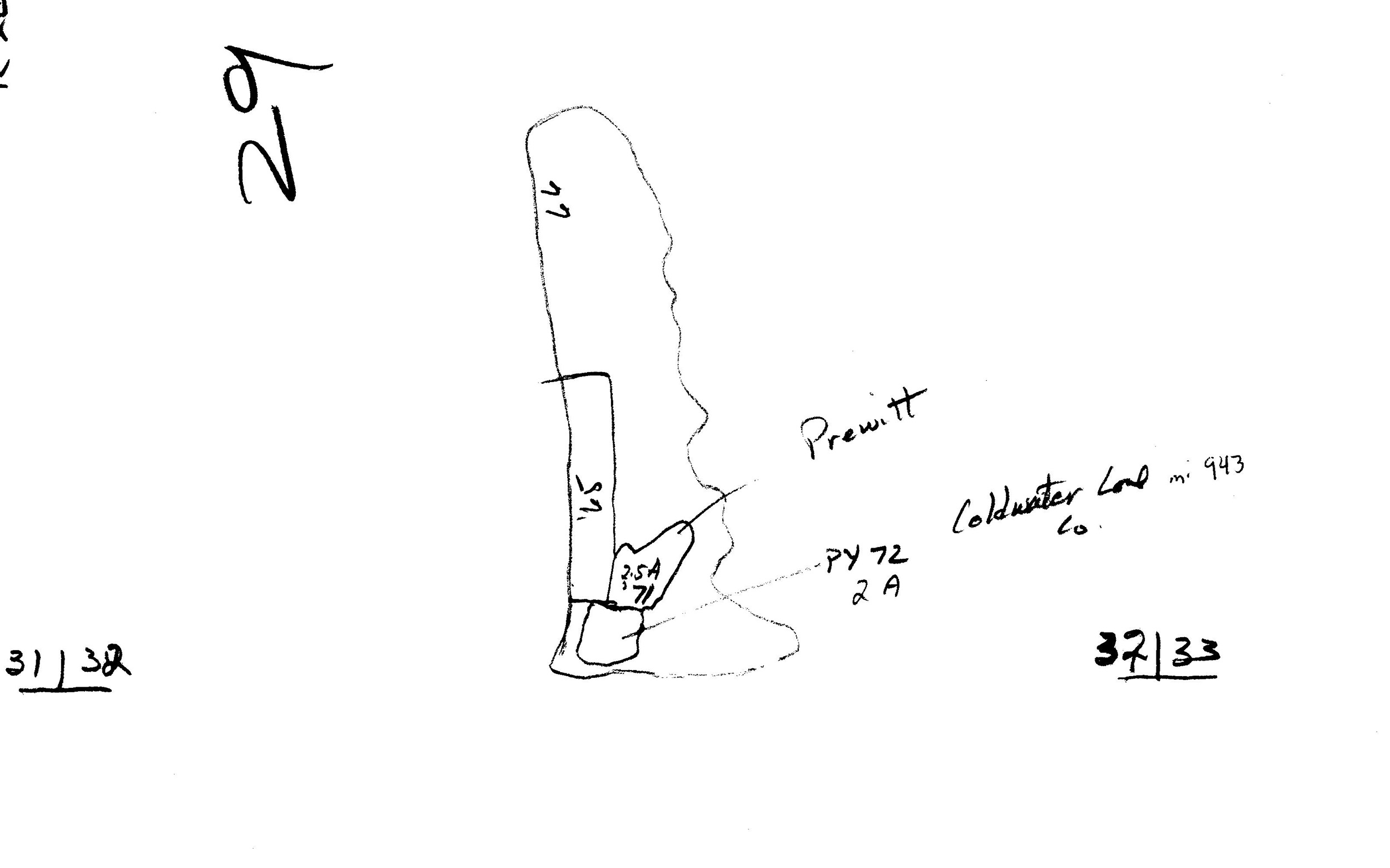
| Total acres shown: | 68 The Cold Water Mines pulled pillars from two abandoned underground mines, the Energy No. 2 Mine (mine index 158) and Miller & Arvipas Mine (mine index 3965), as well as surface mining virgin coal. | ||
| Acres after map date: | General Area of mining acres shown: | ||
Shaft, Slope, Drift or Tipple Location(s)
| Type | County | Township-Range | Section | Part Section |
|---|
| Pit | Williamson | 8S 2E | 32 | E ½ |
Geology
| Thickness (ft) | |||||
|---|---|---|---|---|---|
| Seam | Depth (ft) | Min | Max | Ave | Mining Method |
| Herrin | 20-50 | 7.0-9.0 | Surface |
Geological Problems Reported
Production
| Company | Mine Name | Date | Production (tons) |
| Cold Water Coal Company | Cold Water No. 1 | 1970-1978 | 102,169 |
| Cold Water Coal Company | Cold Water No. 2 | 1979-1980 | 4,263 |
Production Notes
Coal Report production (if available)
Sources of Data
| Source Map | Map Date | Original Scale | Digitized Scale | Map Type |
| Coal Section strip mine updates | 1976 | 1:8400 | 1:8400 | Secondary source |
Annotated Bibliography (Data source - brief description of information)
| Coal Reports - Production, ownership, years of operation, depth, thickness. |
| Directory of Illinois Coal Mines (Williamson County) - Mine names, mine index, ownership, years of operation. |
| Mine notes (Williamson County) - Mine type, mine location, seam, mining method. |
| Coal Section strip mine updates, tracings of aerial photographs - Mine outline. |
Mine Notes
Mine Images

Photographs
Additional Notes