3307: Difference between revisions
Alan.Myers (talk | contribs) No edit summary |
Kate.O'Brien (talk | contribs) No edit summary |
||
| Line 45: | Line 45: | ||
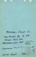
|Company=Marshall Equipment Company | |Company=Marshall Equipment Company | ||
|Mine-Name=Mary Ann No. 1 | |Mine-Name=Mary Ann No. 1 | ||
|minename_note=(Pits 1 | |minename_note=(Pits 1 and 2) | ||
|Date=1960-1965 | |Date=1960-1965 | ||
|Production=824,842 | |Production=824,842 | ||
Revision as of 21:48, February 4, 2022
Mine Index Number: 3307
| Company Name: | Marshall Equipment Company | ||
|---|---|---|---|
| Mine Name: | Mary Ann No. 1 Mine | ||
| Start Date: | 1960 | End Date: | September 1965 |
| Type of Mine: | Surface | ||
| Total acres shown: | NoneProduction indicates approximately 70 acres were mined. | ||
| Acres after map date: | 70 | General Area of mining acres shown: | |
Shaft, Slope, Drift or Tipple Location(s)
| Type | County | Township-Range | Section | Part Section |
|---|
| Pit | Saline | 9S 7E | 23 | SW SW |
Geology
| Thickness (ft) | |||||
|---|---|---|---|---|---|
| Seam | Depth (ft) | Min | Max | Ave | Mining Method |
| Springfield | 50-60 | 4.0-5.33 | Surface |
Geological Problems Reported
Production
| Company | Mine Name | Date | Production (tons) |
| Marshall Equipment Company | Mary Ann No. 1(Pits 1 and 2) | 1960-1965 | 824,842 |
Production Notes
Coal Report production (if available)
Sources of Data
| Source Map | Map Date | Original Scale | Digitized Scale | Map Type |
| ISGS map library, 4102 a-7, sheet 2 | 1981-1983 | 1:24000 | 1:24000 | Secondary source |
Annotated Bibliography (Data source - brief description of information)
| Coal Reports - Production, ownership, years of operation, seam, depth, thickness, mining method. |
| Directory of Illinois Coal Mines (Saline County) - Mine names, mine index, ownership, years of operation. |
| Mine notes (Saline County) - Mine type. |
| ISGS map library, 4102 a-7, sheet 2, work map for Rudement Quadrangle Geologic Map - Mine location. |
Mine Notes
Mine Images
Photographs