3329: Difference between revisions
Kate.O'Brien (talk | contribs) (Created page with "{{Sidebar Info Query}} {{Header |checked=1st Entry |unlocated=No |shown_on_map=Yes |Mine-index=3329 |Coal_co=Bennett Coal Company |Mine Name Header=Bennett No. 2 Mine |mine_ty...") |
Alan.Myers (talk | contribs) No edit summary |
||
| (One intermediate revision by one other user not shown) | |||
| Line 1: | Line 1: | ||
{{Sidebar Info Query}} | {{Sidebar Info Query}} | ||
{{Header | {{Header | ||
|checked= | |checked=Checked OK | ||
|unlocated=No | |unlocated=No | ||
|shown_on_map=Yes | |shown_on_map=Yes | ||
| Line 8: | Line 8: | ||
|Mine Name Header=Bennett No. 2 Mine | |Mine Name Header=Bennett No. 2 Mine | ||
|mine_type=Surface | |mine_type=Surface | ||
|mined-out-area=None{{#info: | |mined-out-area=None {{#info:This mine is not shown on the accompanying map. The seam mined is not known and both the Herrin and Springfield Coals were surface-mined in this section. Surface mining occurred throughout the section, and it is likely that this small mine’s outline is included within one of the larger mines in this section.|note}} | ||
|after_map=Less than 1 | |||
|county1=Saline | |county1=Saline | ||
|quad1=Rudement | |quad1=Rudement | ||
|year-start=1959 | |year-start=1959 | ||
|year-end=1960 | |year-end=February 1960 | ||
|Latitude= | |Latitude=37.66661599 | ||
|Longitude= | |Longitude=-88.4017487 | ||
|Zoom=15 | |Zoom=15 | ||
}} | }} | ||
| Line 42: | Line 43: | ||
|Date=1959-1960 | |Date=1959-1960 | ||
|Production=1,052 | |Production=1,052 | ||
|Sum=Yes | |||
}} | }} | ||
===Production Notes=== | ===Production Notes=== | ||
Latest revision as of 14:58, April 14, 2022
Mine Index Number: 3329
| Company Name: | Bennett Coal Company | ||
|---|---|---|---|
| Mine Name: | Bennett No. 2 Mine | ||
| Start Date: | 1959 | End Date: | February 1960 |
| Type of Mine: | Surface | ||
| Total acres shown: | None This mine is not shown on the accompanying map. The seam mined is not known and both the Herrin and Springfield Coals were surface-mined in this section. Surface mining occurred throughout the section, and it is likely that this small mine’s outline is included within one of the larger mines in this section. | ||
| Acres after map date: | Less than 1 | General Area of mining acres shown: | |
Shaft, Slope, Drift or Tipple Location(s)
| Type | County | Township-Range | Section | Part Section |
|---|
| Tipple / pit | Saline | 10S 7E | 11 |
Geology
| Thickness (ft) | |||||
|---|---|---|---|---|---|
| Seam | Depth (ft) | Min | Max | Ave | Mining Method |
| Surface |
Geological Problems Reported
Production
| Company | Mine Name | Date | Production (tons) |
| Bennett Coal Company | Bennett No. 2 | 1959-1960 | 1,052 |
| Total Production: 1,052 | |||
Production Notes
Coal Report production (if available)
Sources of Data
| Source Map | Map Date | Original Scale | Digitized Scale | Map Type |
| Mine notes | Undated | (text only) | Secondary source |
Annotated Bibliography (Data source - brief description of information)
| Coal Reports - Production, ownership, years of operation, mining method. |
| Directory of Illinois Coal Mines (Saline County) - Mine names, mine index, ownership, years of operation. |
| Mine notes (Saline County) - Mine type, mine location. |
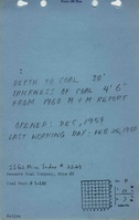
Mine Notes
Mine Images
Photographs