4114: Difference between revisions
No edit summary |
Alan.Myers (talk | contribs) No edit summary |
||
| Line 14: | Line 14: | ||
|year-start=1889 | |year-start=1889 | ||
|year-end=1909 | |year-end=1909 | ||
|Latitude= | |Latitude=37.70279038 | ||
|Longitude= | |Longitude=-88.79360904 | ||
|Zoom=15 | |Zoom=15 | ||
}} | }} | ||
| Line 47: | Line 47: | ||
|Date=1889-1902 {{#info: Idle 1896|note}} | |Date=1889-1902 {{#info: Idle 1896|note}} | ||
|Production=6,735 | |Production=6,735 | ||
|Sum=No | |||
}} | }} | ||
{{Production | {{Production | ||
| Line 53: | Line 54: | ||
|Date=1902-1903 | |Date=1902-1903 | ||
|Production=1,258 | |Production=1,258 | ||
|Sum=No | |||
}} | }} | ||
{{Production | {{Production | ||
| Line 59: | Line 61: | ||
|Date=1903-1909 | |Date=1903-1909 | ||
|Production=8,128 | |Production=8,128 | ||
|Sum=No | |||
| | |||
}} | }} | ||
{{Production | {{Production | ||
|Production=16,121 | |Production=16,121 | ||
|Sum=Yes | |||
}} | }} | ||
===Production Notes=== | ===Production Notes=== | ||
Latest revision as of 11:05, April 15, 2022
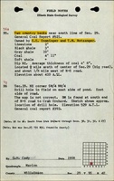
Mine Index Number: 4114
| Company Name: | E. E. Ensminger | ||
|---|---|---|---|
| Mine Name: | Ensminger Mine | ||
| Start Date: | 1889 | End Date: | 1909 |
| Type of Mine: | Underground | ||
| Total acres shown: | None | ||
| Acres after map date: | 3 | General Area of mining acres shown: | |
Shaft, Slope, Drift or Tipple Location(s)
| Type | County | Township-Range | Section | Part Section |
|---|
| Main drift | Williamson | 9S 4E | 29 | SW SE SW |
Geology
| Thickness (ft) | |||||
|---|---|---|---|---|---|
| Seam | Depth (ft) | Min | Max | Ave | Mining Method |
| Springfield | 14-45 | 4.0-8.0 | RP |
Geological Problems Reported
Production
| Company | Mine Name | Date | Production (tons) |
| E. E. Ensminger | Ensminger | 1889-1902 Idle 1896 | 6,735 |
| Ensminger and Rentfro | Ensminger and Rentfro | 1902-1903 | 1,258 |
| E. E. Ensminger | Ensminger | 1903-1909 | 8,128 |
| Total Production: 16,121 | |||
Production Notes
Coal Report production (if available)
Sources of Data
| Source Map | Map Date | Original Scale | Digitized Scale | Map Type |
| Mine notes | Undated | (text only) | 1:24000 Point plotted onto 1:24,000 USGS topographic map and digitized. | Secondary source |
Annotated Bibliography (Data source - brief description of information)
| Coal Reports - Production, ownership, years of operation, depth, thickness, mining method. |
| Directory of Illinois Coal Mines (Williamson County) - Mine names, mine index, ownership, years of operation. |
| Mine notes (Williamson County) - Mine type, drift location, seam, thickness. |
Mine Notes
Mine Images
Photographs