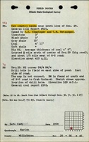
Mine Index Number: 4114
| Company Name:
|
E. E. Ensminger
|
| Mine Name:
|
Ensminger Mine
|
| Start Date:
|
1889
|
End Date:
|
1909
|
| Type of Mine:
|
Underground
|
| Total acres shown:
|
None
|
| Acres after map date:
|
3
|
General Area of mining acres shown:
|
|
|
|
Shaft, Slope, Drift or Tipple Location(s)
| Type
|
County
|
Township-Range
|
Section
|
Part Section
|
| Main drift
|
Williamson
|
9S 4E
|
29
|
SW SE SW
|
Geology
| Springfield
|
14-45
|
|
|
4.0-8.0
|
RP
|
Geological Problems Reported
Production
| Company
|
Mine Name
|
Date
|
Production (tons)
|
Production Notes
Coal Report production (if available)
Sources of Data
| Mine notes
|
Undated
|
(text only)
|
1:24000 Point plotted onto 1:24,000 USGS topographic map and digitized.
|
Secondary source
|
Annotated Bibliography (Data source - brief description of information)
| Coal Reports - Production, ownership, years of operation, depth, thickness, mining method.
|
| Directory of Illinois Coal Mines (Williamson County) - Mine names, mine index, ownership, years of operation.
|
| Mine notes (Williamson County) - Mine type, drift location, seam, thickness.
|
Mine Notes
Mine Images
Photographs