3990: Difference between revisions
No edit summary |
No edit summary |
||
| Line 64: | Line 64: | ||
|Mine-Name=McNeil | |Mine-Name=McNeil | ||
|Date=1909-1914 | |Date=1909-1914 | ||
|Production= | |Production=40,800 | ||
|Sum=No | |Sum=No | ||
}} | }} | ||
| Line 89: | Line 89: | ||
}} | }} | ||
{{Production | {{Production | ||
|Production= | |Production=64,062 | ||
|Sum=Yes | |Sum=Yes | ||
}} | }} | ||
Revision as of 16:13, June 23, 2022
Mine Index Number: 3990
| Company Name: | Waldron and Brayfield | ||
|---|---|---|---|
| Mine Name: | Waldron and Brayfield Mine | ||
| Start Date: | 1903 | End Date: | 1917 |
| Type of Mine: | Underground | ||
| Total acres shown: | None This area was later surface mined by mine index 4433, an unidentified surface mine. | ||
| Acres after map date: | General Area of mining acres shown: | ||
|
Not Shown On Map. | |||
Shaft, Slope, Drift or Tipple Location(s)
| Type | County | Township-Range | Section | Part Section |
|---|
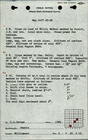
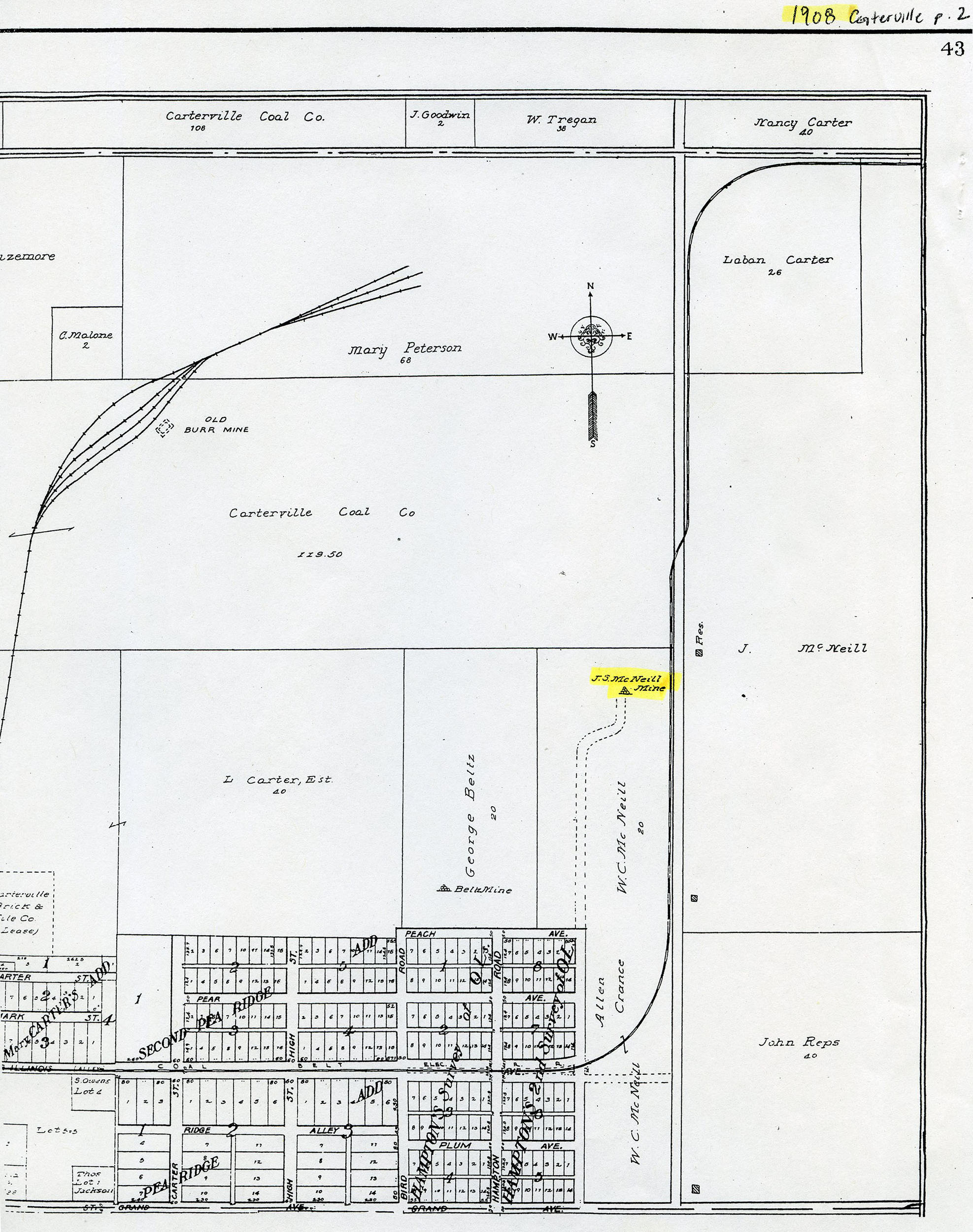
| Main slope | Williamson | 9S 1E | 2 | NE NW SE |
Geology
| Thickness (ft) | |||||
|---|---|---|---|---|---|
| Seam | Depth (ft) | Min | Max | Ave | Mining Method |
| Herrin | 12 | 9 | UG |
Geological Problems Reported
Production
| Company | Mine Name | Date | Production (tons) |
| Thomas Parrett | Parrett | 1903-1906 Idle 1905-1906; reported abandoned in 1906 Coal Report | 749 |
| J. S. McNeil | McNeil | 1906-1908 | 12,000 |
| Tom Parritt | Parritt | 1908-1909 | 4,800 |
| J. S. McNeil | McNeil | 1909-1914 | 40,800 |
| Carlisle and McNeil | Carlisle and McNeil | 1914-1915 | 2,094 |
| Waldron and Brayfield | Waldron and Brayfield | 1915-1916 | 3,619 |
| W. J. John | John | 1916-1917 | unreported |
| Total Production: 64,062 | |||
Production Notes
Coal Report production (if available)
Sources of Data
| Source Map | Map Date | Original Scale | Digitized Scale | Map Type |
| Atlas of Williamson County | 1908 | 1:8665 | 1:8665 | Secondary source |
Annotated Bibliography (Data source - brief description of information)
| Coal Reports - Production, ownership, years of operation, mining method. |
| Directory of Illinois Coal Mines (Williamson County) - Mine names, mine index, ownership, years of operation. |
| Mine notes (Williamson County) - Seam, depth, thickness. |
| Atlas of Williamson County, 1908 - Slope location. |
Mine Notes
Mine Images
Photographs