4569: Difference between revisions
Alan.Myers (talk | contribs) No edit summary |
No edit summary |
||
| Line 1: | Line 1: | ||
{{Sidebar Info Query}} | {{Sidebar Info Query}} | ||
{{Header | {{Header | ||
|checked= | |checked=Checked OK | ||
|unlocated=No | |unlocated=No | ||
|shown_on_map=No | |shown_on_map=No | ||
|reason_nsm=Not shown on accompanying map because of later surface mining | |reason_nsm=Not shown on accompanying map because of later surface mining by Forsyth-Energy Inc., Energy Mine (mine index [[0882]]). | ||
|Mine-index=4569 | |Mine-index=4569 | ||
|Coal_co=Unknown | |Coal_co=Unknown | ||
|mine_type=Underground | |||
|indicated=No | |||
|county1=Williamson | |county1=Williamson | ||
|quad1=Herrin | |quad1=Herrin | ||
|year-start=9999 | |year-start=9999 | ||
|year-end=9999 | |year-end=9999 | ||
}} | }} | ||
==Shaft, Slope, Drift or Tipple Location(s)== | ==Shaft, Slope, Drift or Tipple Location(s)== | ||
| Line 19: | Line 18: | ||
{{Shaft locations header}} | {{Shaft locations header}} | ||
{{Shaft locations | {{Shaft locations | ||
|shaft_type=Slope | |||
|County=Williamson | |County=Williamson | ||
|Town-Range=9S 2E | |Town-Range=9S 2E | ||
| Line 39: | Line 39: | ||
{{Source map header}} | {{Source map header}} | ||
{{Source Map | {{Source Map | ||
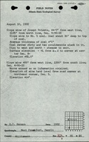
|Source Map= | |Source Map=ISGS field notes (E.T. Benson) | ||
|Map Date=1932 | |Map Date=8-10-1932 | ||
|Original Scale=(text only) | |||
|Digitized Scale=1:24000 {{#info: The mine location was plotted on a 1:24,000 USGS topographic map from the mine location description and digitized.|note}} | |||
|Map Type=Secondary source | |||
}} | }} | ||
{{Annotated bibliography header}} | {{Annotated bibliography header}} | ||
{{Annotated bibliography | |||
|bibliography=ISGS field notes (Williamson County) - Slope location. | |||
}} | |||
==Mine Notes== | ==Mine Notes== | ||
Revision as of 15:48, August 5, 2022
Mine Index Number: 4569
| Company Name: | Unknown | ||
|---|---|---|---|
| Mine Name: | |||
| Start Date: | Unknown | End Date: | Unknown |
| Type of Mine: | Underground | ||
| Total acres shown: | |||
| Acres after map date: | General Area of mining acres shown: | ||
|
Not Shown On Map. Not shown on accompanying map because of later surface mining by Forsyth-Energy Inc., Energy Mine (mine index 0882). | |||
Shaft, Slope, Drift or Tipple Location(s)
| Type | County | Township-Range | Section | Part Section |
|---|
| Slope | Williamson | 9S 2E | 4 | NW SW SW |
Geology
| Thickness (ft) | |||||
|---|---|---|---|---|---|
| Seam | Depth (ft) | Min | Max | Ave | Mining Method |
Geological Problems Reported
Production
| Company | Mine Name | Date | Production (tons) |
Production Notes
Coal Report production (if available)
Sources of Data
| Source Map | Map Date | Original Scale | Digitized Scale | Map Type |
| ISGS field notes (E.T. Benson) | 8-10-1932 | (text only) | 1:24000 The mine location was plotted on a 1:24,000 USGS topographic map from the mine location description and digitized. | Secondary source |
Annotated Bibliography (Data source - brief description of information)
| ISGS field notes (Williamson County) - Slope location. |
Mine Notes
Mine Images
Photographs