3971: Difference between revisions
No edit summary |
No edit summary |
||
| Line 73: | Line 73: | ||
|Source Map=Mine notes | |Source Map=Mine notes | ||
|Map Date=Undated | |Map Date=Undated | ||
|Original Scale= | |Original Scale=1:62500 | ||
|Digitized Scale=1:24000 | |Digitized Scale=1:24000 | ||
|Map Type=Secondary source | |Map Type=Secondary source | ||
}} | }} | ||
Revision as of 10:57, October 4, 2022
Mine Index Number: 3971
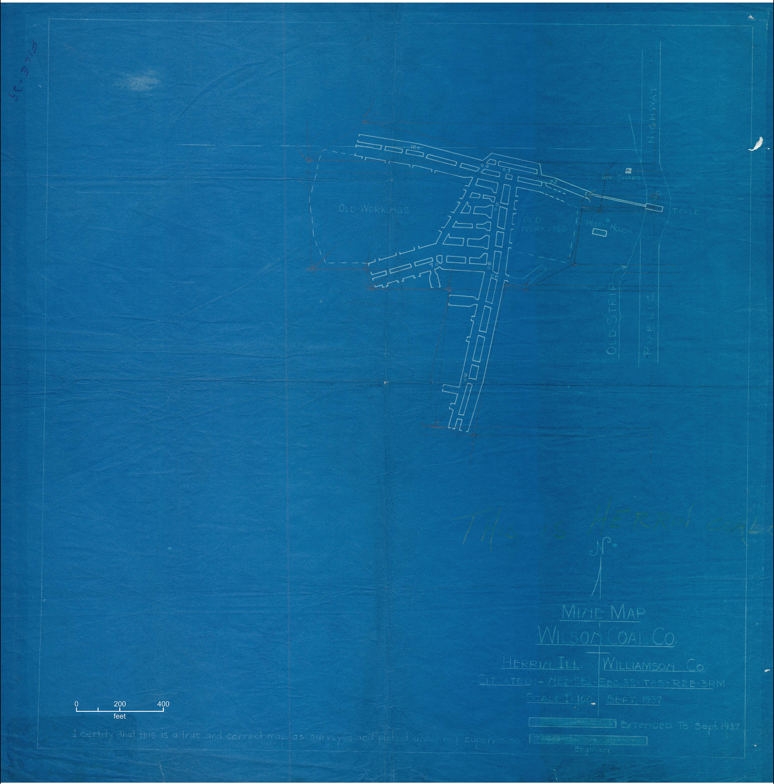
| Company Name: | Herrin Coal Company | ||
|---|---|---|---|
| Mine Name: | Herrin Mine | ||
| Start Date: | 1936 | End Date: | 1940 |
| Type of Mine: | Underground | ||
| Total acres shown: | None | ||
| Production Indicated Acres: | 3 | General Area of mining acres shown: | |
Shaft, Slope, Drift or Tipple Location(s)
| Type | County | Township-Range | Section | Part Section |
|---|
| Main slope | Williamson | 8S 2E | 32 | SE NE SE |
Geology
| Thickness (ft) | |||||
|---|---|---|---|---|---|
| Seam | Depth (ft) | Min | Max | Ave | Mining Method |
| Springfield | 75 | 4.0 | RP |
Geological Problems Reported
Production
| Company | Mine Name | Date | Production (tons) |
| Roy Wilson Coal Company | Wilson No. 3 | 1936-1938 | 10,192 |
| Herrin Coal Company | Herrin | 1938-1940 | 4,877 |
| Total Production: 15,069 | |||
Production Notes
Coal Report production (if available)
Sources of Data
| Source Map | Map Date | Original Scale | Digitized Scale | Map Type |
| Mine notes | Undated | 1:62500 | 1:24000 | Secondary source |
Annotated Bibliography (Data source - brief description of information)
| Coal Reports - Production, ownership, years of operation, mining method. |
| Directory of Illinois Coal Mines (Williamson County) - Mine names, mine index, ownership, years of operation. |
| Mine notes (Williamson County) - Mine type, slope location, seam, depth, thickness. |
Mine Notes
Mine Images
Photographs