3490: Difference between revisions
Alan.Myers (talk | contribs) No edit summary |
No edit summary |
||
| (6 intermediate revisions by 3 users not shown) | |||
| Line 1: | Line 1: | ||
{{Sidebar Info Query}} | {{Sidebar Info Query}} | ||
{{Header | {{Header | ||
|checked=Checked OK | |||
|unlocated=No | |unlocated=No | ||
|shown_on_map=Yes | |shown_on_map=Yes | ||
| Line 9: | Line 10: | ||
|mined-out-area=128 | |mined-out-area=128 | ||
|after_map=13 | |after_map=13 | ||
|indicated=No | |||
|county1=St. Clair | |county1=St. Clair | ||
|quad1= | |quad1=Mascoutah | ||
|year-start= | |datemod=Pre | ||
|year-start=1882 | |||
|year-end=1936 | |year-end=1936 | ||
|Latitude=38.491757659 | |Latitude=38.491757659 | ||
|Longitude=-89.870435876 | |Longitude=-89.870435876 | ||
|Zoom=14 | |||
}} | }} | ||
==Shaft, Slope, Drift or Tipple Location(s)== | ==Shaft, Slope, Drift or Tipple Location(s)== | ||
| Line 44: | Line 48: | ||
}} | }} | ||
===Geological Problems Reported=== | ===Geological Problems Reported=== | ||
Gas was reported at this mine. Some | Gas was reported at this mine. Some concretions were present in both the roof shale and the coal. | ||
==Production== | ==Production== | ||
| Line 54: | Line 58: | ||
|Date=pre1882-1889 | |Date=pre1882-1889 | ||
|Production=81,010 {{#info: Ownership and production prior to 1882 unknown. The Coal Report of 1882 indicates 12 acres mined.|note}} | |Production=81,010 {{#info: Ownership and production prior to 1882 unknown. The Coal Report of 1882 indicates 12 acres mined.|note}} | ||
|Sum=No | |||
}} | }} | ||
{{Production | {{Production | ||
| Line 60: | Line 65: | ||
|Date=1889-1890 | |Date=1889-1890 | ||
|Production=18,500 | |Production=18,500 | ||
|Sum=No | |||
}} | }} | ||
{{Production | {{Production | ||
| Line 66: | Line 72: | ||
|Date=1890-1900 | |Date=1890-1900 | ||
|Production=98,030 | |Production=98,030 | ||
|Sum=No | |||
}} | }} | ||
{{Production | {{Production | ||
| Line 73: | Line 80: | ||
|Date=1900-1907 | |Date=1900-1907 | ||
|Production=192,930 | |Production=192,930 | ||
|Sum=No | |||
}} | }} | ||
{{Production | {{Production | ||
| Line 79: | Line 87: | ||
|Date=1907-1910 | |Date=1907-1910 | ||
|Production=78,359 | |Production=78,359 | ||
|Sum=No | |||
}} | }} | ||
{{Production | {{Production | ||
| Line 85: | Line 94: | ||
|Date=1910-1916 {{#info: Idle 1914-1916|note}} | |Date=1910-1916 {{#info: Idle 1914-1916|note}} | ||
|Production=75,976 | |Production=75,976 | ||
|Sum=No | |||
}} | }} | ||
{{Production | {{Production | ||
| Line 92: | Line 102: | ||
|Date=1916-1919 | |Date=1916-1919 | ||
|Production=43,541 | |Production=43,541 | ||
|Sum=No | |||
}} | }} | ||
{{Production | {{Production | ||
| Line 98: | Line 109: | ||
|Date=1919-1922 | |Date=1919-1922 | ||
|Production=67,499 | |Production=67,499 | ||
|Sum=No | |||
}} | }} | ||
{{Production | {{Production | ||
| Line 104: | Line 116: | ||
|Date=1922-1929 | |Date=1922-1929 | ||
|Production=36,693 | |Production=36,693 | ||
|Sum=No | |||
}} | }} | ||
{{Production | {{Production | ||
| Line 110: | Line 123: | ||
|Date=1930-1930 | |Date=1930-1930 | ||
|Production=7,001 | |Production=7,001 | ||
|Sum=No | |||
}} | }} | ||
{{Production | {{Production | ||
| Line 116: | Line 130: | ||
|Date=1931-1931 | |Date=1931-1931 | ||
|Production=8,959 | |Production=8,959 | ||
|Sum=No | |||
}} | }} | ||
{{Production | {{Production | ||
| Line 122: | Line 137: | ||
|Date=1932-1932 | |Date=1932-1932 | ||
|Production=12,550 | |Production=12,550 | ||
|Sum=No | |||
}} | }} | ||
{{Production | {{Production | ||
| Line 128: | Line 144: | ||
|Date=1933-1936 | |Date=1933-1936 | ||
|Production=80,591 | |Production=80,591 | ||
|Sum=No | |||
| | |||
}} | }} | ||
{{Production | {{Production | ||
|Production=801,639 | |Production=801,639 | ||
|Sum=Yes | |||
}} | }} | ||
===Production Notes=== | ===Production Notes=== | ||
| Line 156: | Line 171: | ||
}} | }} | ||
{{Annotated bibliography | {{Annotated bibliography | ||
|bibliography= | |bibliography=Mine notes (St. Clair County) - Mine type, shaft size, shaft location, seam, depth, thickness. | ||
}} | }} | ||
{{Annotated bibliography | {{Annotated bibliography | ||
|bibliography= | |bibliography=Land Bank Report - Depth, thickness. | ||
}} | }} | ||
{{Annotated bibliography | {{Annotated bibliography | ||
|bibliography= | |bibliography=Microfilm map, document 351092, reel 03134, frame 204 - Shaft locations, mine outline, mining method. | ||
}} | }} | ||
==Mine Notes== | ==Mine Notes== | ||
| Line 173: | Line 188: | ||
{{Photo Query}} | {{Photo Query}} | ||
{{Editwithform}} | {{Editwithform}} | ||
{{#set: Company=Liberty Coal Company}} | {{#set: Company=Liberty Coal Company}} | ||
Latest revision as of 17:07, October 25, 2022
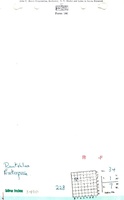
Mine Index Number: 3490
| Company Name: | Rentchler Fuel Company | ||
|---|---|---|---|
| Mine Name: | Enterprise Mine | ||
| Start Date: | Pre 1882 | End Date: | 1936 |
| Type of Mine: | Underground | ||
| Total acres shown: | 128 | ||
| Acres after map date: | 13 | General Area of mining acres shown: | |
Shaft, Slope, Drift or Tipple Location(s)
| Type | County | Township-Range | Section | Part Section |
|---|
| Main shaft (5.5'x12') | St. Clair | 1N 7W | 34 | NE SW NW |
| Shaft | St. Clair | 1N 7W | 34 | SE SW NW |
Geology
| Thickness (ft) | |||||
|---|---|---|---|---|---|
| Seam | Depth (ft) | Min | Max | Ave | Mining Method |
| Herrin | 93-114 | 6.5-7.25 | MRP,RPBsome RPB |
Geological Problems Reported
Gas was reported at this mine. Some concretions were present in both the roof shale and the coal.
Production
| Company | Mine Name | Date | Production (tons) |
| Adam Ogden | Enterprise | pre1882-1889 | 81,010 Ownership and production prior to 1882 unknown. The Coal Report of 1882 indicates 12 acres mined. |
| Enterprise | Enterprise | 1889-1890 | 18,500 |
| William Ogden and Brother | Enterprise | 1890-1900 | 98,030 |
| Enterprise Mining Company | Enterprise, Ogden | 1900-1907 | 192,930 |
| Central Indiana Coal Mining Company | Enterprise | 1907-1910 | 78,359 |
| Gouch Coal and Mining Company | Enterprise | 1910-1916 Idle 1914-1916 | 75,976 |
| Enterprise Collieries Company The mine notes indicate this mine was operated by Liberty Coal Company in 1917. | Enterprise No. 1 | 1916-1919 | 43,541 |
| L. and N. Coal Mining Company | Enterprise | 1919-1922 | 67,499 |
| Lou-Nash Coal and Mining Company | Enterprise | 1922-1929 | 36,693 |
| Piazza and Marfia Coal Company | Enterprise | 1930-1930 | 7,001 |
| Enterprise Coal and Mining Company | Enterprise | 1931-1931 | 8,959 |
| Piazza Coal Company | Enterprise | 1932-1932 | 12,550 |
| Rentchler Fuel Company | Enterprise | 1933-1936 | 80,591 |
| Total Production: 801,639 | |||
Production Notes
Coal Report production (if available)
Sources of Data
| Source Map | Map Date | Original Scale | Digitized Scale | Map Type |
| Microfilm, document 351092 | 1-8-1932 | 1:2400 | 1:4138 | Not final |
Annotated Bibliography (Data source - brief description of information)
| Coal Reports - Production, ownership, years of operation. |
| Directory of Illinois Coal Mines (St. Clair County) - Mine names, mine index, ownership, years of operation. |
| Mine notes (St. Clair County) - Mine type, shaft size, shaft location, seam, depth, thickness. |
| Land Bank Report - Depth, thickness. |
| Microfilm map, document 351092, reel 03134, frame 204 - Shaft locations, mine outline, mining method. |
Mine Notes
Mine Images

Photographs