Mine Index Number: 3490
| Company Name:
|
Rentchler Fuel Company
|
| Mine Name:
|
Enterprise Mine
|
| Start Date:
|
Pre 1882
|
End Date:
|
1936
|
| Type of Mine:
|
Underground
|
| Total acres shown:
|
128
|
| Acres after map date:
|
13
|
General Area of mining acres shown:
|
|
|
|
Shaft, Slope, Drift or Tipple Location(s)
| Type
|
County
|
Township-Range
|
Section
|
Part Section
|
| Main shaft (5.5'x12')
|
St. Clair
|
1N 7W
|
34
|
NE SW NW
|
| Shaft
|
St. Clair
|
1N 7W
|
34
|
SE SW NW
|
Geology
| Herrin
|
93-114
|
|
|
6.5-7.25
|
MRP,RPBsome RPB
|
Geological Problems Reported
Gas was reported at this mine. Some concretions were present in both the roof shale and the coal.
Production
| Company
|
Mine Name
|
Date
|
Production (tons)
|
| Adam Ogden
|
Enterprise
|
pre1882-1889
|
81,010 Ownership and production prior to 1882 unknown. The Coal Report of 1882 indicates 12 acres mined.
|
|
|
|
|
|
|
|
| Total Production: 801,639
|
Production Notes
Coal Report production (if available)
Sources of Data
| Microfilm, document 351092
|
1-8-1932
|
1:2400
|
1:4138
|
Not final
|
Annotated Bibliography (Data source - brief description of information)
| Coal Reports - Production, ownership, years of operation.
|
| Directory of Illinois Coal Mines (St. Clair County) - Mine names, mine index, ownership, years of operation.
|
| Mine notes (St. Clair County) - Mine type, shaft size, shaft location, seam, depth, thickness.
|
| Land Bank Report - Depth, thickness.
|
| Microfilm map, document 351092, reel 03134, frame 204 - Shaft locations, mine outline, mining method.
|
Mine Notes
Mine Images
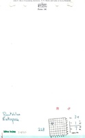
Microfilm: 351092
Map Date: 1-8-1932
Coal Co.: Rentchler Fuel Company
Mine Name: Enterprise Mine
Full Res Download
Photographs