Category:Gillespie South-Quadrangle: Difference between revisions
Alan.Myers (talk | contribs) (Created page with "{{County-Page}}") |
Alan.Myers (talk | contribs) No edit summary |
||
| Line 1: | Line 1: | ||
{{County- | __NOTOC__ | ||
==Mining in the Gillespie South Quadrangle== | |||
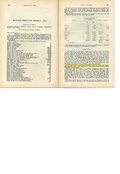
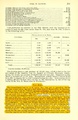
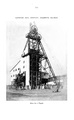
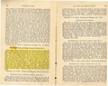
The mines in the Gillespie South Quadrangle operated for long periods, with only two of the ten operating for less than 20 years. The longest-running mine was the Staunton No. 7 Mine ([[0189|mine index 189]]), which operated for over 70 years. The four Superior Coal Company mines operated between 36 and 48 years each, and were among the most productive mines in the state during World War I. Employment at these mines was fairly stable during the Great Depression in spite of frequent idling of the mines, the result of an agreement between the Superior Coal Company and the unions to share out the work among the men instead of layoffs. | |||
The coal thickness in the Gillespie South Quadrangle ranged from below 5 feet thick to over 9 feet thick. Depths ranged from 290 to about 350 feet. | |||
The roof conditions described in several mines were similar. Below the persistent, competent limestone was a crumbly gray shale, then a green and brown shale. Below that was a lenticular limestone that ranged from 0 to 12 inches thick, with a light gray shale (usually referred to as “clod”) and below that a massive black shale. The clod and dark gray shale did not hold very well. Some mines left 14 to 22 inches of top coal to help keep the roof up, but some roof falls went to the upper limestone. Leaving the top coal protected the shale from the changes in humidity and other effects of weathering, and slowed the deterioration. Most of these mines operated prior to roof bolting (the earliest roof bolting was in this area in 1947, in Staunton No. 7 Mine, [[0189|mine index 189]]), and timbering was used to keep the roof up. In another area, limestone protrusions (sometimes referred to as bosses) extended down into the coal seam. They were inferred to be derived by pressure, as the black shale and coal below was usually shattered with pinwheel slips around the protrusions. | |||
==Map and Directory PDF Download== | |||
[https://wikiimage.isgs.illinois.edu/ilmines/webfiles/topo-mines/Gillespie-South.pdf Coal Mines In Illinois Gillespie South Quadrangle]</br> | |||
==Mines that Appear on the Gillespie South Quadrangle== | |||
{{#css: | |||
#mw-subcategories {display: none} | |||
#mw-pages {display: none} | |||
#mw-category-media {display: none} | |||
}} | |||
{{#ask:[[Category:Gillespie South-Quadrangle]] | |||
[[:+]] | |||
[[Unlocated::No]] | |||
|?combined = Coal Company, Mine Name | |||
|?County | |||
|format=datatables|limit=1500|link=all|sort=Mine Index|order=asc|headers=plain|mainlabel=Mine Index|searchlabel=... further results|class=sortable wikitable smwtable|sep=<br>|Default='''Mines for this quadrangle have not been entered into Ilmines-Wiki see download above for more information'''}} | |||
==Unlocated Mines== | |||
===Macoupin County=== | |||
{{#ask:[[Category:Macoupin-County]] | |||
[[:+]] | |||
[[Unlocated::Yes]] | |||
|?combined = Coal Company, Mine Name | |||
|?City | |||
|format=datatables|limit=1500|link=all|sort=Mine Index|order=asc|headers=plain|mainlabel=Mine Index|searchlabel=... further results|default=There are no known Unlocated mines in this county |class=sortable wikitable smwtable|sep=<br>}} | |||
{{DISPLAYTITLE:Gillespie South Quadrangle}} | |||
Latest revision as of 16:08, October 26, 2022
Mining in the Gillespie South Quadrangle
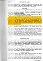
The mines in the Gillespie South Quadrangle operated for long periods, with only two of the ten operating for less than 20 years. The longest-running mine was the Staunton No. 7 Mine (mine index 189), which operated for over 70 years. The four Superior Coal Company mines operated between 36 and 48 years each, and were among the most productive mines in the state during World War I. Employment at these mines was fairly stable during the Great Depression in spite of frequent idling of the mines, the result of an agreement between the Superior Coal Company and the unions to share out the work among the men instead of layoffs.
The coal thickness in the Gillespie South Quadrangle ranged from below 5 feet thick to over 9 feet thick. Depths ranged from 290 to about 350 feet.
The roof conditions described in several mines were similar. Below the persistent, competent limestone was a crumbly gray shale, then a green and brown shale. Below that was a lenticular limestone that ranged from 0 to 12 inches thick, with a light gray shale (usually referred to as “clod”) and below that a massive black shale. The clod and dark gray shale did not hold very well. Some mines left 14 to 22 inches of top coal to help keep the roof up, but some roof falls went to the upper limestone. Leaving the top coal protected the shale from the changes in humidity and other effects of weathering, and slowed the deterioration. Most of these mines operated prior to roof bolting (the earliest roof bolting was in this area in 1947, in Staunton No. 7 Mine, mine index 189), and timbering was used to keep the roof up. In another area, limestone protrusions (sometimes referred to as bosses) extended down into the coal seam. They were inferred to be derived by pressure, as the black shale and coal below was usually shattered with pinwheel slips around the protrusions.
Map and Directory PDF Download
Coal Mines In Illinois Gillespie South Quadrangle
Mines that Appear on the Gillespie South Quadrangle
Unlocated Mines
Macoupin County
Pages in category "Gillespie South-Quadrangle"
The following 32 pages are in this category, out of 32 total.
6
7
M
- FileList:M0066 IL 1124
- FileList:M0068 IL 1123
- FileList:M0073 IL 2620
- FileList:M0073 IL 2646
- FileList:M0073 IL 47
- FileList:M0188 IL 1130
- FileList:M0189 IL 727 03
- FileList:M0189 IL 805 03
- FileList:M0190 IL 1122 01
- FileList:M0190 IL 728
- FileList:M0413 IL 1126
- FileList:M0503 IL 1102
- FileList:M0762 IL 1127 03
- FileList:M2796 IL 1665 01
- FileList:M2796 IL 1731 03
- FileList:M2796 IL 94 01
- FileList:M2897 atlas 1871
- FileList:M7841 1875 atlas
- FileList:M7841 quade
Media in category "Gillespie South-Quadrangle"
The following 33 files are in this category, out of 33 total.
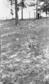 M-1042 Superior Coal Mine no 2 Gillespie.jpg 2,568 × 4,378; 1.29 MB
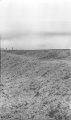 M-1044 sub fill L and M track SE of Staunton Consolidated no 6 mine.jpg 2,572 × 4,350; 1.09 MB
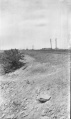 M-1045 sub fill LandM track SE of Staunton Consolidated no 6 mine.jpg 2,584 × 4,338; 1.32 MB
 M0066 coalreport1905.pdf 633 × 977; 101 KB
 M0066 coalreport1906.pdf 1,679 × 1,283; 382 KB
 M0066 minenotes.pdf 731 × 1,202, 39 pages; 18.29 MB
 M0068 coalreport1904.pdf 1,675 × 1,237; 398 KB
 M0068 coalreport1905.pdf 633 × 977; 88 KB
 M0068 minenotes.pdf 731 × 1,202, 27 pages; 14.9 MB
 M0073 coalreport1905 p324.pdf 633 × 977; 127 KB
 M0073 minenotes.pdf 731 × 1,202, 28 pages; 7.08 MB
 M0188 coalreport1917.pdf 602 × 991; 82 KB
 M0188 coalreport1943.pdf 625 × 1,016; 112 KB
 M0188 minenotes.pdf 731 × 1,202, 103 pages; 26.99 MB
 M0189 coalreport1884.pdf 1,587 × 1,260; 362 KB
 M0189 coalreport1885.pdf 1,652 × 1,293; 817 KB
 M0189 coalreport1912.pdf 1,641 × 1,241, 2 pages; 765 KB
 M0189 minenotes.pdf 731 × 1,202, 33 pages; 13.02 MB
 M0190 coalreport1903.pdf 1,552 × 1,239; 309 KB
 M0190 coalreport1904.pdf 1,675 × 1,237; 399 KB
 M0190 minenotes.pdf 731 × 1,202, 14 pages; 3.62 MB
 M0413 coalreport1903.pdf 1,552 × 1,239; 308 KB
 M0413 coalreport1904.pdf 1,641 × 1,227, 2 pages; 879 KB
 M0413 minenotes.pdf 731 × 1,202, 28 pages; 12.74 MB
 M0503 coalreport1904.pdf 1,641 × 1,227, 2 pages; 879 KB
 M0503 minenotes.pdf 733 × 1,202, 51 pages; 13.45 MB
 M0762 coalreport1884.pdf 1,587 × 1,260; 366 KB
 M0762 minenotes.pdf 731 × 1,202, 5 pages; 1.1 MB
 M2796 coalreport1897 p120.pdf 839 × 1,185; 190 KB
 M2796 minenotes.pdf 731 × 1,202, 6 pages; 1.44 MB
 M2897 coalreport1884.pdf 1,600 × 1,266, 2 pages; 622 KB
 M2897 minenotes.pdf 731 × 1,202, 4 pages; 888 KB
 M6692 minenotes.pdf 733 × 1,202; 236 KB


