|
|
| Line 10: |
Line 10: |
| |mine_type=Underground | | |mine_type=Underground |
| |mined-out-area=None | | |mined-out-area=None |
| |after_map=10 | | |after_map=8 |
| |indicated=Yes | | |indicated=Yes |
| |county1=Williamson | | |county1=Williamson |
Latest revision as of 15:31, November 7, 2022
Mine Index Number: 3990
| Company Name:
|
Waldron and Brayfield
|
| Mine Name:
|
Waldron and Brayfield Mine
|
| Start Date:
|
1903
|
End Date:
|
1917
|
| Type of Mine:
|
Underground
|
| Total acres shown:
|
None
|
| Production Indicated Acres:
|
8
|
General Area of mining acres shown:
|
|
|
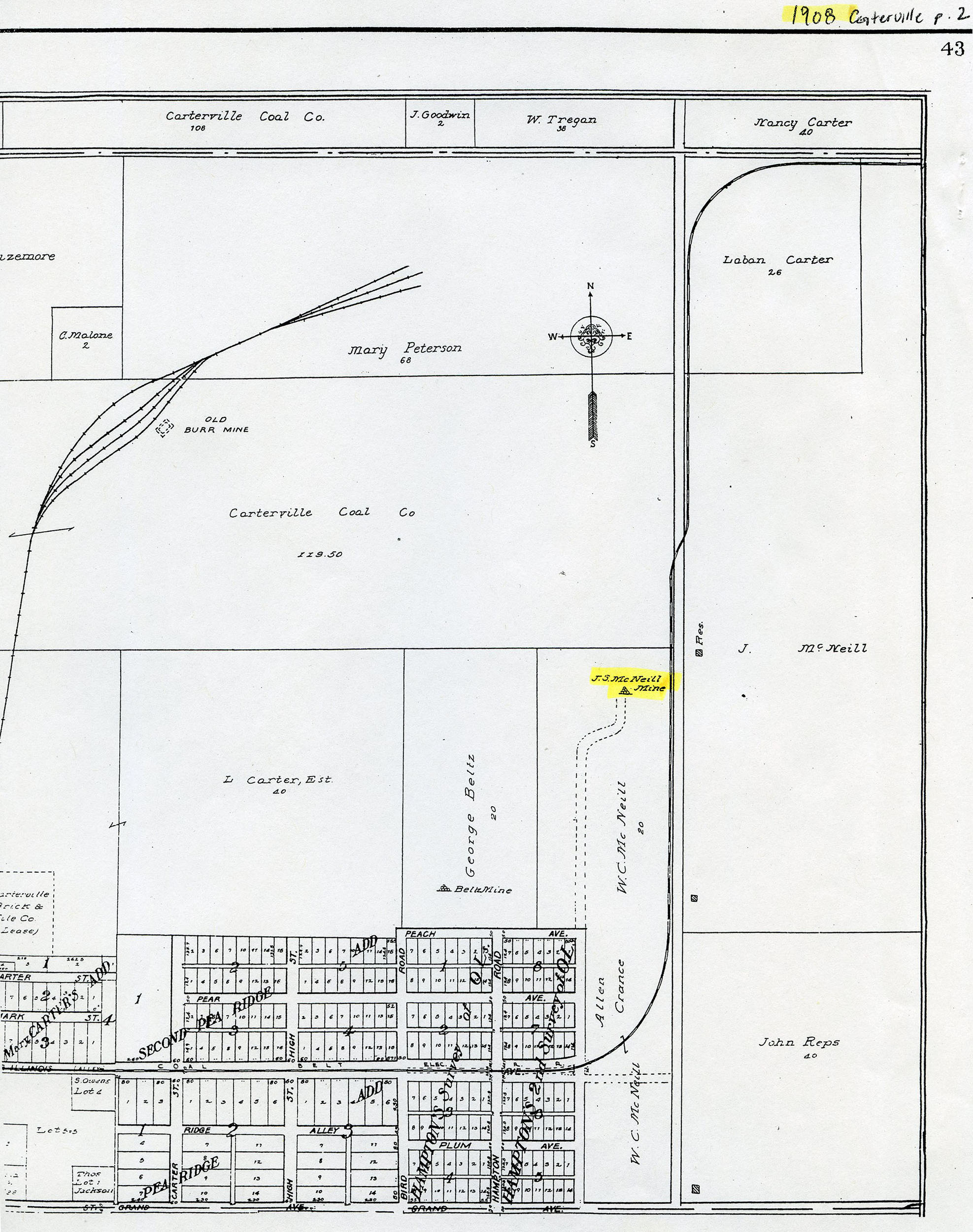
Not Shown On Map. This area was later surface mined by mine index 4433, an unidentified surface mine.
|
Shaft, Slope, Drift or Tipple Location(s)
| Type
|
County
|
Township-Range
|
Section
|
Part Section
|
| Main slope
|
Williamson
|
9S 1E
|
2
|
NE NW SE
|
Geology
Geological Problems Reported
Production
| Company
|
Mine Name
|
Date
|
Production (tons)
|
Production Notes
Coal Report production (if available)
Sources of Data
| Standard Atlas of Williamson County
|
1908
|
1:8665
|
1:8665
|
Secondary source
|
Annotated Bibliography (Data source - brief description of information)
| Coal Reports - Production, ownership, years of operation, mining method.
|
| Directory of Illinois Coal Mines (Williamson County) - Mine names, mine index, ownership, years of operation.
|
| Mine notes (Williamson County) - Seam, depth, thickness.
|
| Standard Atlas of Williamson County, Illinois, published by Geo. A. Ogle & Co., Chicago, 1908 - Slope location.
|
Mine Notes
Mine Images
 These files may not be true to scale and are not georgistered. These files may not be true to scale and are not georgistered.
|
Map Type:
|
Historical Atlas
|
| Map ID:
|
1908 Atlas of Williamson County
|
| Company:
|
|
| Mine Name:
|
|
| Caption:
|
|
| Map Date:
|
1908
|
| Map Status:
|
Secondary
|
| Image Credit:
|
|
| Note:
|
|
| More Info:
|
M3990.jpg
|
| Full Res Download:These files are true to scale and most are georegistered for gis software. These files may be a very large (>1GB) download!
|
https://wikiimage.isgs.illinois.edu/ilmines/williamson/m3988-m3990.zip
|
Photographs