3971: Difference between revisions
No edit summary |
No edit summary |
||
| (2 intermediate revisions by one other user not shown) | |||
| Line 3: | Line 3: | ||
|checked=Checked OK | |checked=Checked OK | ||
|unlocated=No | |unlocated=No | ||
|shown_on_map=Yes | |||
|Mine-index=3971 | |Mine-index=3971 | ||
|Coal_co=Herrin Coal Company | |Coal_co=Herrin Coal Company | ||
| Line 15: | Line 16: | ||
|year-start=1936 | |year-start=1936 | ||
|year-end=1940 | |year-end=1940 | ||
|Latitude=37. | |Latitude=37.77889332 | ||
|Longitude=-89. | |Longitude=-89.00316509 | ||
|Zoom=14 | |Zoom=14 | ||
}} | }} | ||
| Line 53: | Line 54: | ||
|Company=Roy Wilson Coal Company | |Company=Roy Wilson Coal Company | ||
|Mine-Name=Wilson No. 3 | |Mine-Name=Wilson No. 3 | ||
|Date=1936-1938 | |Date=1936-1937 | ||
|Production= | |Production=6,795 | ||
|Sum=No | |||
}} | |||
{{Production | |||
|Company=Roy Wilson Coal Company | |||
|Mine-Name=Wilson No. 3 | |||
|Date=1937-1938 | |||
|Production=3,397 {{#info: Production after map date|note}} | |||
|Sum=No | |Sum=No | ||
}} | }} | ||
| Line 61: | Line 69: | ||
|Mine-Name=Herrin | |Mine-Name=Herrin | ||
|Date=1938-1940 | |Date=1938-1940 | ||
|Production=4,877 | |Production=4,877 {{#info: Production after map date|note}} | ||
|Sum=No | |Sum=No | ||
}} | }} | ||
Latest revision as of 12:04, February 1, 2023
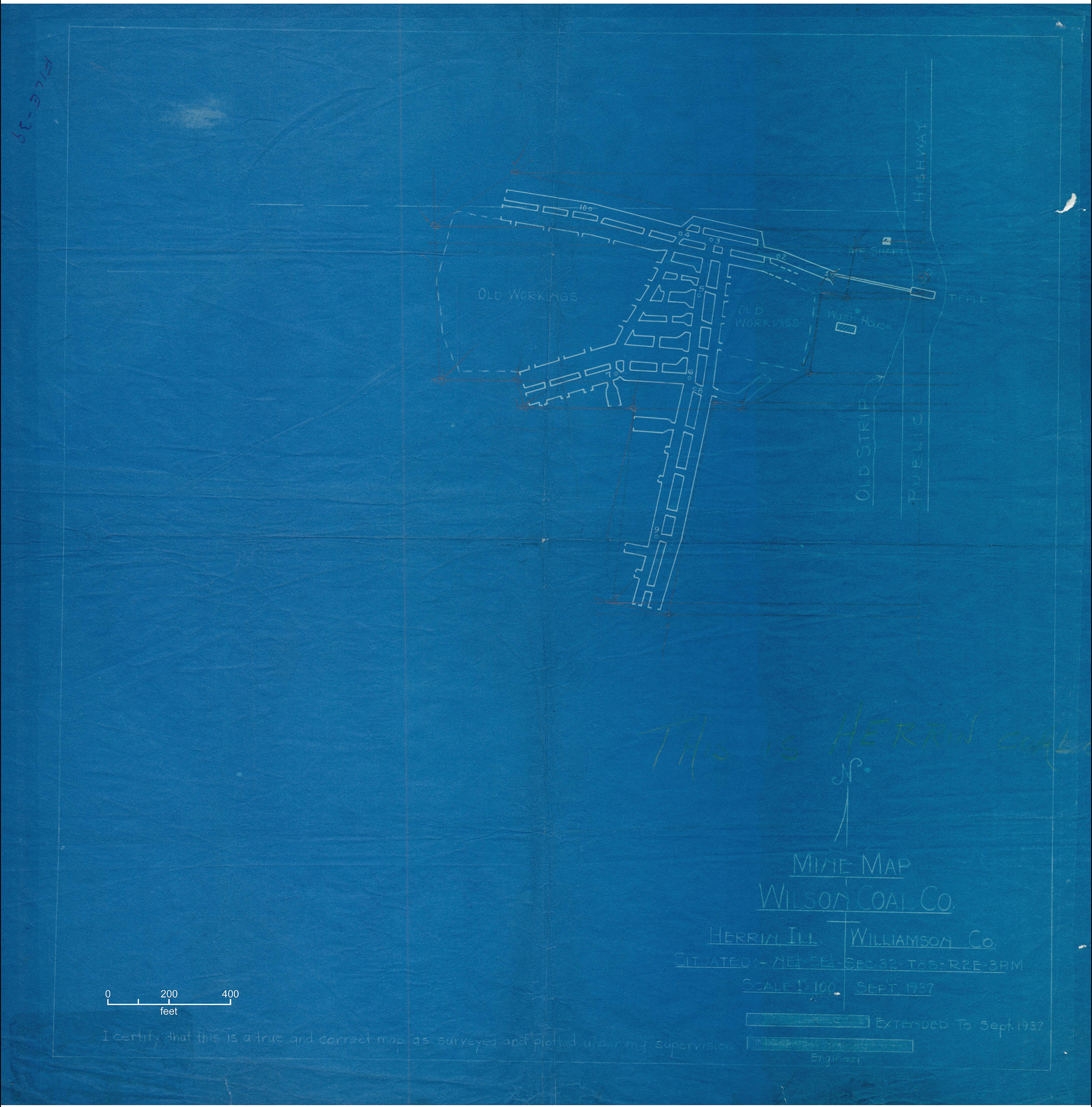
Mine Index Number: 3971
| Company Name: | Herrin Coal Company | ||
|---|---|---|---|
| Mine Name: | Herrin Mine | ||
| Start Date: | 1936 | End Date: | 1940 |
| Type of Mine: | Underground | ||
| Total acres shown: | 19 | ||
| Production Indicated Acres: | 3 | General Area of mining acres shown: | 2, to include air shaft in outline shown |
Shaft, Slope, Drift or Tipple Location(s)
| Type | County | Township-Range | Section | Part Section |
|---|
| Main slope | Williamson | 8S 2E | 32 | SE NE SE |
| Air shaft | Williamson | 8S 2E | 32 | SE NE SE |
Geology
| Thickness (ft) | |||||
|---|---|---|---|---|---|
| Seam | Depth (ft) | Min | Max | Ave | Mining Method |
| Springfield | 75 | 4.0 | RP |
Geological Problems Reported
Production
| Company | Mine Name | Date | Production (tons) |
| Roy Wilson Coal Company | Wilson No. 3 | 1936-1937 | 6,795 |
| Roy Wilson Coal Company | Wilson No. 3 | 1937-1938 | 3,397 Production after map date |
| Herrin Coal Company | Herrin | 1938-1940 | 4,877 Production after map date |
| Total Production: 15,069 | |||
Production Notes
Coal Report production (if available)
Sources of Data
| Source Map | Map Date | Original Scale | Digitized Scale | Map Type |
| State archive, IL_1514_01 | 9-1937 | 1:2400 | 1:2400 | Not final |
Annotated Bibliography (Data source - brief description of information)
| Coal Reports - Production, ownership, years of operation, mining method. |
| Directory of Illinois Coal Mines (Williamson County) - Mine names, mine index, ownership, years of operation. |
| State archive, IL_1514_01 - Slope and shaft locations, mine outline, mining method. |
| Mine notes (Williamson County) - Mine type, slope location, seam, depth, thickness. |
Mine Notes
Mine Images
Photographs