0003: Difference between revisions
Kate.O'Brien (talk | contribs) No edit summary |
No edit summary |
||
| (3 intermediate revisions by 2 users not shown) | |||
| Line 1: | Line 1: | ||
{{Sidebar Info Query}} | {{Sidebar Info Query}} | ||
{{Header | {{Header | ||
|checked= | |checked=Checked OK | ||
|unlocated=No | |unlocated=No | ||
|shown_on_map=Yes | |shown_on_map=Yes | ||
| Line 9: | Line 9: | ||
|mine_type=Underground | |mine_type=Underground | ||
|mined-out-area=1,274{{#info:The boundaries between the La Salle Mine, the Rockwell Mine (mine index 238), and the Kentucky Mine (mine index 5660) could not be distinguished. The area shown includes all three mines.|note}} | |mined-out-area=1,274{{#info:The boundaries between the La Salle Mine, the Rockwell Mine (mine index 238), and the Kentucky Mine (mine index 5660) could not be distinguished. The area shown includes all three mines.|note}} | ||
|indicated=No | |||
|county1=La Salle | |county1=La Salle | ||
|quad1=La Salle | |quad1=La Salle | ||
|city1=La Salle | |||
|year-start=1856 | |year-start=1856 | ||
|year-end=January 1930 | |year-end=January 1930 | ||
|Latitude= | |Latitude=41.32772314 | ||
|Longitude= | |Longitude=-89.08651184 | ||
|Zoom=15 | |Zoom=15 | ||
}} | }} | ||
| Line 21: | Line 23: | ||
{{Shaft locations header}} | {{Shaft locations header}} | ||
{{Shaft locations | {{Shaft locations | ||
|shaft_type=Main shaft{{#info:An escape road was shown on the source map, connecting to the Jones Mine (mine index 273). Text on the source map also indicates the Rockwell Shaft (mine index 238) may have been kept open for escape purposes for the La Salle Mine as well.|note}} | |shaft_type=Main shaft {{#info:An escape road was shown on the source map, connecting to the Jones Mine (mine index 273). Text on the source map also indicates the Rockwell Shaft (mine index 238) may have been kept open for escape purposes for the La Salle Mine as well.|note}} | ||
|County=La Salle | |County=La Salle | ||
|Town-Range=33N 1E | |Town-Range=33N 1E | ||
| Line 37: | Line 39: | ||
|thick-ave=3.5 | |thick-ave=3.5 | ||
|mining-method=LW | |mining-method=LW | ||
|mining-method_note= (old longwall) | |||
}} | }} | ||
===Geological Problems Reported=== | ===Geological Problems Reported=== | ||
| Line 47: | Line 50: | ||
|Company=La Salle Coal Mining Company | |Company=La Salle Coal Mining Company | ||
|Mine-Name=La Salle | |Mine-Name=La Salle | ||
|Date=1856-1883{{#info:The 1882 Coal Report indicated 450 acres had been mined. Production before July 1881 is unknown.|note}} | |Date=1856-1883 {{#info:The 1882 Coal Report indicated 450 acres had been mined. Production before July 1881 is unknown.|note}} | ||
|Production=145,556 | |Production=145,556 | ||
|Sum=No | |Sum=No | ||
| Line 86: | Line 89: | ||
}} | }} | ||
{{Annotated bibliography | {{Annotated bibliography | ||
|bibliography=Bedford, | |bibliography=Bedford, Willam T., 1911, Twentieth Anniversary Souvenir Edition; The La Salle Tribune 1891-1911, printed & published at LaSalle, Illinois , re-published by LaSalle County Genealogy Guild, 1996, 206p. - Ownership, years of operation. | ||
}} | }} | ||
{{Annotated bibliography | {{Annotated bibliography | ||
Latest revision as of 09:59, February 6, 2023
Mine Index Number: 0003
| Company Name: | La Salle County Carbon Coal Company | ||
|---|---|---|---|
| Mine Name: | La Salle Mine | ||
| Start Date: | 1856 | End Date: | January 1930 |
| Type of Mine: | Underground | ||
| Total acres shown: | 1,274The boundaries between the La Salle Mine, the Rockwell Mine (mine index 238), and the Kentucky Mine (mine index 5660) could not be distinguished. The area shown includes all three mines. | ||
| Acres after map date: | General Area of mining acres shown: | ||
Shaft, Slope, Drift or Tipple Location(s)
| Type | County | Township-Range | Section | Part Section |
|---|
| Main shaft An escape road was shown on the source map, connecting to the Jones Mine (mine index 273). Text on the source map also indicates the Rockwell Shaft (mine index 238) may have been kept open for escape purposes for the La Salle Mine as well. | La Salle | 33N 1E | 15 | NE SE SE |
Geology
| Thickness (ft) | |||||
|---|---|---|---|---|---|
| Seam | Depth (ft) | Min | Max | Ave | Mining Method |
| Colchester | 390-420 | 2.5 | 4.0 | 3.5 | LW (old longwall) |
Geological Problems Reported
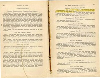
Very little timbering was needed for the gray shale roof. It arched well and the gob packs behind the advancing longwall provided adequate support. Black shale made up the roof locally, and ranged from 1 to 3 feet thick. This black shale came down easily and contained concretions. The coal was thinner under the black shale. The roof was poor near slips and rolls. The coal contained pyrite bands and balls as well as sheets of calcite and pyrite along cleavage planes. A persistent band of pyrite balls occurred 21 inches from the top of the seam.
Production
| Company | Mine Name | Date | Production (tons) |
| La Salle Coal Mining Company | La Salle | 1856-1883 The 1882 Coal Report indicated 450 acres had been mined. Production before July 1881 is unknown. | 145,556 |
| La Salle County Carbon Coal Company | La Salle | 1883-1930 | 4,634,623 |
| Total Production: 4,780,179 | |||
Production Notes
Coal Report production (if available)
Sources of Data
| Source Map | Map Date | Original Scale | Digitized Scale | Map Type |
| Microfilm, document 352407 | 1-3-1930 | 1:2400 | 1:4634 | Final |
Annotated Bibliography (Data source - brief description of information)
| Coal Reports - Production, ownership, years of operation, depth, thickness, mining method. |
| Directory of Illinois Coal Mines (La Salle County) - Mine names, mine index, ownership, years of operation. |
| Mine notes (La Salle County) - Mine type, shaft location, seam, depth, thickness, geologic problems. |
| Bedford, Willam T., 1911, Twentieth Anniversary Souvenir Edition; The La Salle Tribune 1891-1911, printed & published at LaSalle, Illinois , re-published by LaSalle County Genealogy Guild, 1996, 206p. - Ownership, years of operation. |
| Microfilm map, document 352407, reel 03139, frames 66-69 - Shaft locations, mine outline, mining method. |
Mine Notes
Mine Images
Photographs