La Salle Quadrangle
Mining in the La Salle Quadrangle
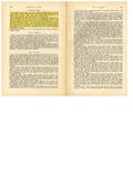
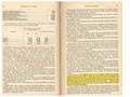
The earliest known mining in the county was Dixwell Lathrop’s mine near the (later abandoned) town of Rockwell, east of La Salle in 1839 (Haeger, 1983). The precise location of the mine is not known (and is not shown on the accompanying map). The mine did not operate long, and was probably quite small, since the town only had 26 inhabitants in 1840, after illness had devastated the community and most of the remaining population fled the area.
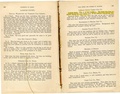
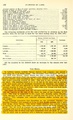
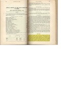
The first large commercial coal mine opened in the county was the La Salle Shaft (mine index 3), which hoisted its first coal in June of 1856, quickly followed by the Kentucky Shaft (mine index 5660), which first hoisted coal in October 1856. Mining may have occurred in three seams: the Danville Coal was called the First Vein, the Herrin Coal was called the Second Vein, and the Colchester Coal was called the Third Vein. No maps have been found depicting mining in the First Vein, but mining surely took place in the most accessible coal. The Danville Coal is over 3.5 feet thick under La Salle and between 2.3 and 3.5 feet thick under Peru. Few maps have survived of mining in the Herrin Coal, and more mining probably took place in this seam than is shown on the accompanying maps.
Most of the surviving company maps are of coal mines in the Colchester Coal, which was mined by the longwall method. The Union Mine (mine index 755) operated until 1946 for a total of 75 years and the Illinois Zinc No. 3 Mine (mine index 358) operated until 1949 for a total of 67 years.
Map and Directory PDF Download
Coal Mines In Illinois La Salle Quadrangle
Mines that Appear on the La Salle Quadrangle
Unlocated Mines
La Salle County
Pages in category "La Salle Quadrangle"
The following 52 pages are in this category, out of 52 total.
Media in category "La Salle Quadrangle"
The following 41 files are in this category, out of 41 total.
 M0002 coalreport1884.pdf 1,639 × 1,287; 297 KB
 M0002 coalreport1904.pdf 1,652 × 1,214; 371 KB
 M0002 fieldnotes.pdf 747 × 1,193; 224 KB
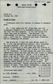
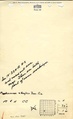
 M0002 minenotes.pdf 731 × 1,202, 22 pages; 5.2 MB
 M0003 coalreport1884.pdf 1,639 × 1,287; 299 KB
 M0003 minenotes.pdf 733 × 1,202, 20 pages; 5.11 MB
 M0009 minenotes.pdf 731 × 1,202, 22 pages; 4.57 MB
 M0102 coalreport1906.pdf 1,675 × 1,256; 450 KB
 M0102 coalreport1907.pdf 587 × 966, 2 pages; 166 KB
 M0102 minenotes.pdf 733 × 1,204, 13 pages; 3.36 MB
 M0231 coalreport1900.pdf 1,514 × 1,183; 329 KB
 M0231 coalreport1915.pdf 1,654 × 1,275, 2 pages; 664 KB
 M0231 fieldnotes.pdf 752 × 1,197, 2 pages; 382 KB
 M0231 minenotes.pdf 733 × 1,202, 37 pages; 8.25 MB
 M0238 coalreport1884.pdf 1,639 × 1,287; 297 KB
 M0238 minenotes.pdf 733 × 1,202, 7 pages; 1.62 MB
 M0273 minenotes.pdf 731 × 1,202, 15 pages; 3.86 MB
 M0358 minenotes.pdf 731 × 1,202, 20 pages; 8.88 MB
 M0755 minenotes.pdf 731 × 1,202, 8 pages; 1.99 MB
 M2651 minenotes.pdf 733 × 1,204, 2 pages; 351 KB
 M2652 minenotes.pdf 733 × 1,204, 2 pages; 373 KB
 M2653 minenotes.pdf 733 × 1,204, 3 pages; 603 KB
 M2654 fieldnotes.pdf 756 × 1,191; 285 KB
 M2654 minenotes.pdf 733 × 1,204, 3 pages; 591 KB
 M2655 minenotes.pdf 733 × 1,204, 2 pages; 354 KB
 M2656 fieldnotes.pdf 750 × 1,197; 290 KB
 M2656 minenotes.pdf 733 × 1,204, 3 pages; 625 KB
 M2657 minenotes.pdf 733 × 1,204, 2 pages; 392 KB
 M2658 minenotes.pdf 733 × 1,204, 3 pages; 578 KB
 M2668 fieldnotes.pdf 750 × 1,193; 209 KB
 M2668 minenotes.pdf 733 × 1,202, 2 pages; 363 KB
 M2669 minenotes.pdf 731 × 1,202, 2 pages; 376 KB
 M2677 minenotes.pdf 731 × 1,202, 2 pages; 373 KB
 M2678 fieldnotes.pdf 752 × 1,187, 2 pages; 369 KB
 M2678 minenotes.pdf 731 × 1,202, 6 pages; 1.54 MB
 M2679 minenotes.pdf 731 × 1,202, 6 pages; 1.39 MB
 M2684 minenotes.pdf 731 × 1,202, 3 pages; 618 KB
 M5493 minenotes.pdf 733 × 1,204, 3 pages; 638 KB
 M5528 minenotes.pdf 731 × 1,202, 2 pages; 361 KB
 M6648 minenotes.pdf 731 × 1,202, 4 pages; 849 KB
 M90995652 minenotes.pdf 733 × 1,202, 2 pages; 371 KB