Mine Index Number: 0231
| Company Name:
|
Matthiessen and Hegeler Zinc Company
|
| Mine Name:
|
Matthiessen and Hegeler Mine
|
| Start Date:
|
1874
|
End Date:
|
1937
|
| Type of Mine:
|
Underground
|
| Total acres shown:
|
46 in the Herrin Coal, 1,139 in the Colchester Coal Mining may have taken place in the Danville Coal as well.
|
| Production Indicated Acres:
|
20
|
General Area of mining acres shown:
|
|
|
|
Shaft, Slope, Drift or Tipple Location(s)
| Type
|
County
|
Township-Range
|
Section
|
Part Section
|
| Main shaft (Herrin)
|
La Salle
|
33N 1E
|
14
|
NW NW NW
|
| Air shaft (Herrin)
|
La Salle
|
33N 1E
|
14
|
NW NW NW
|
| Shaft
|
La Salle
|
33N 1E
|
22
|
SE SW SE
|
| Slope (Colchester)
|
La Salle
|
33N 1E
|
11
|
SE SW SW
|
| Shaft (Colchester)
|
La Salle
|
33N 1E
|
10
|
NE SE SE
|
Geology
| Colchester
|
480
|
|
|
3.5
|
LW, RPP (old longwall)
|
Geological Problems Reported
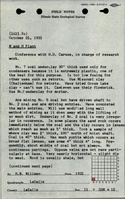
One fault was observed. The roof was 0 to 8 feet of black shale overlain by gray shale and sandstone. The roof was bad in some parts of the mine. Some rolls could be traced for more than a half mile and were more than 70 feet wide. Numerous horsebacks and clay veins occurred in the Herrin Coal. In the northwestern part of the mine, considerable difficulty was encountered with the great prevalence of irregularities in the nature of the horsebacks. In the western part of the mine, the inserted material of the horsebacks was composed of micaceous sandstone instead of clay. In one case, sandstone appeared to be forced in between laminae of coal so that alternate bands of sandstone and coal made up the bulk of the seam. There was no connection between the occurrence of sandstone roof and the sand insertions in the seam or horsebacks. Some pyrite was present in the coal, in balls and lenticular bands. Some areas had thin lenses and masses of sandy clay. The Herrin Coal underclay was used for condensers and for mortar. It was too plastic for many other uses. The roof of the Colchester Coal was generally a gray shale, but sometimes black shale with large concretions made the roof. This coal had a great deal of pyrite, generally near the center of the seam, mostly in broad flat lenses (4 inches thick and 4 feet long, for instance).
Production
| Company
|
Mine Name
|
Date
|
Production (tons)
|
|
|
|
|
|
| Total Production: 5,888,872
|
Production Notes
Coal Report production (if available)
Sources of Data
| Company, 4103.L32 i5.1-4
|
6-13-1936
|
1:2400
|
1:2400
|
Not final
|
| Company, 4103.L32 i5.1-5
|
3-30-1936
|
1:2400
|
1:2400
|
Not final
|
Annotated Bibliography (Data source - brief description of information)
| Coal Reports - Production, ownership, years of operation.
|
| Mine notes (La Salle County) - Mine type, shaft location, seam, depth, thickness, mining method, geologic problems.
|
| ISGS field notes (La Salle County), H. B. Willman, 10-21-1931 - Mine location, seams, thickness, mining method, geologic problems.
|
| La Salle Centennial Committee, 1952, La Salle, Illinois, An Historical Sketch - Years of operation.
|
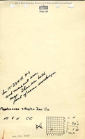
| Company map, ISGS map library, 4103.L32 i5.1-4, Herrin Coal - Shaft locations, mine outline, mining method.
|
| Company map, ISGS map library, 4103.L32 i5.1-5, Colchester Coal - Shaft locations, mine outline, mining method.
|
Mine Notes
Mine Images
Photographs