Mine Index Number: 0002
| Company Name:
|
Oglesby Coal Company
|
| Mine Name:
|
Oglesby Mine
|
| Start Date:
|
1865
|
End Date:
|
January 1919
|
| Type of Mine:
|
Underground
|
| Total acres shown:
|
850
|
| Acres after map date:
|
|
General Area of mining acres shown:
|
|
|
|
Shaft, Slope, Drift or Tipple Location(s)
| Type
|
County
|
Township-Range
|
Section
|
Part Section
|
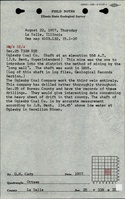
| Main shaft
|
La Salle
|
33N 1E
|
25
|
NE NE SW
|
| Air shaft
|
La Salle
|
33N 1E
|
25
|
NE NE SW
|
Geology
| Colchester
|
460-464
|
3.0
|
4.5
|
3.33-3.75
|
LW (old longwall)
|
Geological Problems Reported
Some faulting was present. One thrust fault was described, and the coal was overthrust for a 16-foot distance, giving a double coal thickness of 7 feet. The roof was gray shale over most of the mine (about 95%). The gray shale was full of slips. Pyrite was present in elongated nodules and lenses parallel to bedding. The roof was reported to be bad where the roof was black shale, because the black shale was filled with slickensided slip planes that caused it to come down in irregular masses. The black shale roof occurred 0 to 18 feet above the coal, and contained concretions up to several feet in diameter. Some rolls were noted. The coal contained pyrite bands and some lenticular nodules of pyrite. In the top of the seam, the pyrite was mixed with carbonaceous dirt. The floor was over 10 feet of fire clay that heaved very badly. This underclay was sandy in some places. The clay was mined where it was free of sand.
Production
| Company
|
Mine Name
|
Date
|
Production (tons)
|
| Kenosha Coal Company T. T. Bent, one of the consortium of owners, introduced longwall mining to this area. This mine was owned by Marquette Cement Company towards the end of its operating period, but continued to report under the old name. ** The 1882 Coal Report indicated 40 acres had been mined. The upper seam was mined from 1865 to 1879, and then not mined until at least 1911. The 40 acres mined may be in one seam or a total for both seams.
|
Oglesby
|
1865-circa 1870
|
unknown
|
|
|
| Oglesby Coal Company
|
Oglesby
|
ca. 1870-1919The 1882 Coal Report indicated 40 acres had been mined. The upper seam was mined from 1865 to 1879, and then not mined until at least 1911. The 40 acres mined may be in one seam or a total for both seams.
|
4,539,689
|
|
|
|
|
|
|
|
| Total Production: 4,539,689
|
Production Notes
Coal Report production (if available)
Sources of Data
| Microfilm, document 352409
|
1-1919
|
1:2400
|
1:4634
|
Final
|
| Company, 4103.L32 i5.1-10
|
5-1910
|
1:2400
|
1:2400
|
Not final
|
Annotated Bibliography (Data source - brief description of information)
| Coal Reports - Production, ownership, years of operation, depth, mining method.
|
| Directory of Illinois Coal Mines (La Salle County) - Mine names, mine index, ownership, years of operation.
|
| Mine notes (La Salle County) - Mine type, shaft location, seam, thickness, geologic problems.
|
| Bedford, Willam T., 1911, Twentieth Anniversary Souvenir Edition; The La Salle Tribune 1891-1911, printed & published at LaSalle, Illinois, re-published by LaSalle County Genealogy Guild, 1996, 206p. - Ownership, seam, depth thickness, years of operation.
|
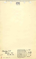
| Microfilm map, document 352409, reel 03139, frames 72 & 73 - Shaft locations, mine outline, mining method.
|
| Company map, ISGS map library, 4103.L32 i5.1-10 - Mine outline (northwestern part).
|
Mine Notes
Mine Images
Photographs