4541: Difference between revisions
(Created page with "{{Sidebar Info Query}} {{Header |checked=1st Entry |unlocated=No |shown_on_map=Yes |Mine-index=4541 |mine_type=Underground |indicated=No |county1=Macoupin |quad1=Hettick |Latitude=0 |Longitude=0 |Zoom=15 }} ==Shaft, Slope, Drift or Tipple Location(s)== {{Shaft locations header}} {{Shaft locations |shaft_type=Main shaft |County=Macoupin |Town-Range=9N 9W |Section=2 |partsection=SW NW NW }} ==Geology== {{Geology seam header}} ===Geological Problems Reported=== ==Product...") |
No edit summary |
||
| Line 1: | Line 1: | ||
{{Sidebar Info Query}} | {{Sidebar Info Query}} | ||
{{Header | {{Header | ||
|checked= | |checked=Checked OK | ||
|unlocated=No | |unlocated=No | ||
|shown_on_map=Yes | |shown_on_map=Yes | ||
|Mine-index=4541 | |Mine-index=4541 | ||
|Coal_co=Chesterfield Coal Company | |||
|Mine Name Header=Chesterfield Mine | |||
|mine_type=Underground | |mine_type=Underground | ||
|indicated=No | |indicated=No | ||
| Line 17: | Line 19: | ||
{{Shaft locations header}} | {{Shaft locations header}} | ||
{{Shaft locations | {{Shaft locations | ||
|shaft_type= | |shaft_type=Mine | ||
|County=Macoupin | |County=Macoupin | ||
|Town-Range=9N 9W | |Town-Range=9N 9W | ||
| Line 31: | Line 33: | ||
{{Production header}} | {{Production header}} | ||
{{Production | |||
|Company=Chesterfield Coal Company | |||
|Mine-Name=Chesterfield | |||
|Date=Unknown | |||
|Production=Unknown | |||
|Sum=No | |||
}} | |||
===Production Notes=== | ===Production Notes=== | ||
| Line 39: | Line 48: | ||
{{Annotated bibliography header}} | {{Annotated bibliography header}} | ||
{{Annotated bibliography | {{Annotated bibliography | ||
|bibliography=Directory of Illinois Coal Mines (Macoupin County) - Mine location. | |bibliography=Directory of Illinois Coal Mines (Macoupin County) - Mine location, mine name. | ||
}} | }} | ||
==Mine Notes== | ==Mine Notes== | ||
Revision as of 11:24, April 17, 2023
Mine Index Number: 4541
| Company Name: | Chesterfield Coal Company | ||
|---|---|---|---|
| Mine Name: | Chesterfield Mine | ||
| Start Date: | {{{year-start}}} | End Date: | {{{year-end}}} |
| Type of Mine: | Underground | ||
| Total acres shown: | |||
| Acres after map date: | General Area of mining acres shown: | ||
"{{{year-start}}}" contains an extrinsic dash or other characters that are invalid for a date interpretation."{{{year-end}}}" contains an extrinsic dash or other characters that are invalid for a date interpretation.
Shaft, Slope, Drift or Tipple Location(s)
| Type | County | Township-Range | Section | Part Section |
|---|
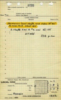
| Mine | Macoupin | 9N 9W | 2 | SW NW NW |
Geology
| Thickness (ft) | |||||
|---|---|---|---|---|---|
| Seam | Depth (ft) | Min | Max | Ave | Mining Method |
Geological Problems Reported
Production
| Company | Mine Name | Date | Production (tons) |
| Chesterfield Coal Company | Chesterfield | Unknown | Unknown |
Production Notes
Coal Report production (if available)
Sources of Data
| Source Map | Map Date | Original Scale | Digitized Scale | Map Type |
Annotated Bibliography (Data source - brief description of information)
| Directory of Illinois Coal Mines (Macoupin County) - Mine location, mine name. |
Mine Notes
Mine Images
Photographs