0188: Difference between revisions
(Created page with "{{Sidebar Info Query}} {{Header |checked=1st Entry |unlocated=No |shown_on_map=Yes |Mine-index=0188 |Coal_co=Superior Coal Company |Mine Name Header=Superior No. 4 Mine |mine_type=Underground |mined-out-area=19,046 {{#info:The boundaries between this mine, Superior No. 1 (mine index 413), Superior No. 2 (mine index 503), and Superior No. 3 (mine index 66) could not be distinguished. The acreage reported is the total for all four mines|note}} |after_map=50 |indicated=Yes...") |
No edit summary |
||
| (6 intermediate revisions by 4 users not shown) | |||
| Line 1: | Line 1: | ||
{{Sidebar Info Query}} | {{Sidebar Info Query}} | ||
{{Header | {{Header | ||
|checked= | |checked=Checked OK | ||
|unlocated=No | |unlocated=No | ||
|shown_on_map=Yes | |shown_on_map=Yes | ||
|reason_nsm=The boundaries between this mine, Superior No. 1 (mine index [[0413]]), Superior No. 2 (mine index [[0503]]), and Superior No. 3 (mine index [[0066]]) could not be distinguished. The acreage reported is the total for all four mines. | |||
|Mine-index=0188 | |Mine-index=0188 | ||
|Coal_co=Superior Coal Company | |Coal_co=Superior Coal Company | ||
|Mine Name Header=Superior No. 4 Mine | |Mine Name Header=Superior No. 4 Mine | ||
|mine_type=Underground | |mine_type=Underground | ||
|mined-out-area=19, | |mined-out-area=19,186 | ||
|indicated=No | |||
|indicated= | |||
|county1=Macoupin | |county1=Macoupin | ||
|quad1=Gillespie South | |quad1=Gillespie South | ||
|quad2=Bunker Hill | |quad2=Bunker Hill | ||
|city1=Gillespie | |||
|year-start=1918 | |year-start=1918 | ||
|year-end=May 1954 | |year-end=May 1954 | ||
|Latitude= | |Latitude=39.06358759 | ||
|Longitude= | |Longitude=-89.85461296 | ||
|Zoom= | |Zoom=12 | ||
}} | }} | ||
==Shaft, Slope, Drift or Tipple Location(s)== | ==Shaft, Slope, Drift or Tipple Location(s)== | ||
| Line 24: | Line 25: | ||
{{Shaft locations header}} | {{Shaft locations header}} | ||
{{Shaft locations | {{Shaft locations | ||
|shaft_type=Main shaft (11 | |shaft_type=Main shaft (11 x 21 ft) | ||
|County=Macoupin | |County=Macoupin | ||
|Town-Range=7N 7W | |Town-Range=7N 7W | ||
| Line 31: | Line 32: | ||
}} | }} | ||
{{Shaft locations | {{Shaft locations | ||
|shaft_type=Air shaft (11 | |shaft_type=Air shaft (11 x 17 ft) | ||
|County=Macoupin | |County=Macoupin | ||
|Town-Range=7N 7W | |Town-Range=7N 7W | ||
| Line 44: | Line 45: | ||
|depth=307-314 | |depth=307-314 | ||
|thick-min=6.0 {{#info:Where the coal was cut out or eroded, the seam thickness was as low as 3 feet.|note}} | |thick-min=6.0 {{#info:Where the coal was cut out or eroded, the seam thickness was as low as 3 feet.|note}} | ||
|thick-max=8.0-8.5 | |||
|thick-ave=7.0-7.5 | |||
|mining-method=RPP | |||
}} | }} | ||
===Geological Problems Reported=== | ===Geological Problems Reported=== | ||
Slips and rock rolls were common in the coal. The rock rolls were nodules or protrusions downward from the limestone roof. These were more common in the | Slips and rock rolls were common in the coal. The rock rolls were nodules or protrusions downward from the limestone roof. These were more common in the eastern side of the mine and decreased to the west. The western workings were very wet; one hypothesis suggested that the moisture seeped in through the slips. Some faults were present, with displacement up to 2 feet or more. In one place, the limestone cap rock was impure and a roof fall included the limestone. Concretions (some limey) were present in the southeastern part of the mine. | ||
==Production== | ==Production== | ||
| Line 55: | Line 59: | ||
|Mine-Name=Superior No. 4 | |Mine-Name=Superior No. 4 | ||
|Date=1918-1953 {{#info:Idle 1933|note}} | |Date=1918-1953 {{#info:Idle 1933|note}} | ||
|Production=24,113, | |Production=24,113,128 | ||
|Sum=No | |Sum=No | ||
}} | }} | ||
| Line 66: | Line 70: | ||
}} | }} | ||
{{Production | {{Production | ||
|Production=24,420, | |Production=24,420,464 | ||
|Sum=Yes | |Sum=Yes | ||
}} | }} | ||
| Line 76: | Line 80: | ||
{{Source map header}} | {{Source map header}} | ||
{{Source Map | {{Source Map | ||
|Source Map= | |Source Map=State archive, IL_1130 | ||
|Map Date= | |Map Date=5-25-1954 | ||
|Original Scale=1:4800 | |Original Scale=1:4800 | ||
|Digitized Scale=1: | |Digitized Scale=1:4800 | ||
|Map Type= | |Map Type=Final | ||
}} | }} | ||
{{Source Map | {{Source Map | ||
|Source Map= | |Source Map=State archive, IL_1124 | ||
|Map Date=10-29-1953 | |Map Date=10-29-1953 | ||
|Original Scale=1:4800 | |Original Scale=1:4800 | ||
|Digitized Scale=1: | |Digitized Scale=1:4800 | ||
|Map Type=Final | |Map Type=Final | ||
}} | }} | ||
{{Source Map | {{Source Map | ||
|Source Map= | |Source Map=State archive, IL_1102 | ||
|Map Date=8-7-1953 | |Map Date=8-7-1953 | ||
|Original Scale=1:4800 | |Original Scale=1:4800 | ||
|Digitized Scale=1: | |Digitized Scale=1:4800 | ||
|Map Type=Final | |Map Type=Final | ||
}} | }} | ||
{{Source Map | {{Source Map | ||
|Source Map= | |Source Map=State archive, IL_1126_03 | ||
|Map Date= | |Map Date=5-9-1951 | ||
|Original Scale=1:4800 | |Original Scale=1:4800 | ||
|Digitized Scale=1: | |Digitized Scale=1:4800 | ||
|Map Type= | |Map Type=Final | ||
}} | }} | ||
{{Annotated bibliography header}} | {{Annotated bibliography header}} | ||
| Line 114: | Line 118: | ||
}} | }} | ||
{{Annotated bibliography | {{Annotated bibliography | ||
|bibliography= | |bibliography=State archive, IL_1130 - Shaft locations, mine outline, mining method. | ||
}} | }} | ||
{{Annotated bibliography | {{Annotated bibliography | ||
|bibliography= | |bibliography=State archive, IL_1124, map of Superior No. 3 (mine index [[0066]]) - Mine outline (west, north). | ||
}} | }} | ||
{{Annotated bibliography | {{Annotated bibliography | ||
|bibliography= | |bibliography=State archive, IL_1102, map of Superior No. 2 (mine index [[0503]]) - Mine outline (southeast, south central). | ||
}} | }} | ||
{{Annotated bibliography | {{Annotated bibliography | ||
|bibliography= | |bibliography=State archive, IL_1126_03, map of Superior No. 1 (mine index [[0413]]) - Mine outline (east, northeast, north central). | ||
}} | }} | ||
==Mine Notes== | ==Mine Notes== | ||
Latest revision as of 15:21, October 17, 2023
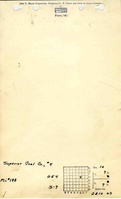
Mine Index Number: 0188
| Company Name: | Superior Coal Company | ||
|---|---|---|---|
| Mine Name: | Superior No. 4 Mine | ||
| Start Date: | 1918 | End Date: | May 1954 |
| Type of Mine: | Underground | ||
| Total acres shown: | 19,186 | ||
| Acres after map date: | General Area of mining acres shown: | ||
|
The boundaries between this mine, Superior No. 1 (mine index 0413), Superior No. 2 (mine index 0503), and Superior No. 3 (mine index 0066) could not be distinguished. The acreage reported is the total for all four mines. | |||
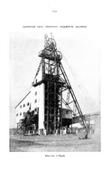
Shaft, Slope, Drift or Tipple Location(s)
| Type | County | Township-Range | Section | Part Section |
|---|
| Main shaft (11 x 21 ft) | Macoupin | 7N 7W | 10 | 30 FSL, 910 FWL, SW NE |
| Air shaft (11 x 17 ft) | Macoupin | 7N 7W | 10 | SE SW NE |
Geology
| Thickness (ft) | |||||
|---|---|---|---|---|---|
| Seam | Depth (ft) | Min | Max | Ave | Mining Method |
| Herrin | 307-314 | 6.0 Where the coal was cut out or eroded, the seam thickness was as low as 3 feet. | 8.0-8.5 | 7.0-7.5 | RPP |
Geological Problems Reported
Slips and rock rolls were common in the coal. The rock rolls were nodules or protrusions downward from the limestone roof. These were more common in the eastern side of the mine and decreased to the west. The western workings were very wet; one hypothesis suggested that the moisture seeped in through the slips. Some faults were present, with displacement up to 2 feet or more. In one place, the limestone cap rock was impure and a roof fall included the limestone. Concretions (some limey) were present in the southeastern part of the mine.
Production
| Company | Mine Name | Date | Production (tons) |
| Superior Coal Company | Superior No. 4 | 1918-1953 Idle 1933 | 24,113,128 |
| Superior Coal Company | Superior No. 4 | 1953-1954 | 307,336 Production after map date |
| Total Production: 24,420,464 | |||
Production Notes
Coal Report production (if available)
Sources of Data
| Source Map | Map Date | Original Scale | Digitized Scale | Map Type |
| State archive, IL_1130 | 5-25-1954 | 1:4800 | 1:4800 | Final |
| State archive, IL_1124 | 10-29-1953 | 1:4800 | 1:4800 | Final |
| State archive, IL_1102 | 8-7-1953 | 1:4800 | 1:4800 | Final |
| State archive, IL_1126_03 | 5-9-1951 | 1:4800 | 1:4800 | Final |
Annotated Bibliography (Data source - brief description of information)
| Coal Reports - Production, ownership, years of operation, shaft sizes. |
| Directory of Illinois Coal Mines (Macoupin County) - Mine names, mine index, ownership, years of operation. |
| Mine notes (Macoupin County) - Mine type, shaft location, seam, depth, thickness, geologic problems. |
| State archive, IL_1130 - Shaft locations, mine outline, mining method. |
| State archive, IL_1124, map of Superior No. 3 (mine index 0066) - Mine outline (west, north). |
| State archive, IL_1102, map of Superior No. 2 (mine index 0503) - Mine outline (southeast, south central). |
| State archive, IL_1126_03, map of Superior No. 1 (mine index 0413) - Mine outline (east, northeast, north central). |
Mine Notes
Mine Images
![[[:Superior No. 2|Superior No. 2]]](https://go.illinois.edu/ILMImages/macoupin/thumbnails/m0503_IL_1102_th.jpg)
![[[:Superior No. 1|Superior No. 1]]](https://go.illinois.edu/ILMImages/macoupin/thumbnails/m0413_IL_1126_th.jpg)
![[[:Superior No. 4|Superior No. 4]]](https://go.illinois.edu/ILMImages/macoupin/thumbnails/m0188_IL_1130_th.jpg)
![[[:Superior No. 3|Superior No. 3]]](https://go.illinois.edu/ILMImages/macoupin/thumbnails/m0066_IL_1124_th.jpg)
Photographs