4538: Difference between revisions
(Created page with "{{Sidebar Info Query}} {{Header |checked=1st Entry |unlocated=No |shown_on_map=Yes |Mine-index=4538 |mine_type=Underground |indicated=No |county1=Macoupin |quad1=Shipman |Latitude=0 |Longitude=0 |Zoom=15 }} ==Shaft, Slope, Drift or Tipple Location(s)== {{Shaft locations header}} {{Shaft locations |shaft_type=Main shaft |County=Macoupin |Town-Range=7N 9W |Section=35 |partsection=SE SE NE }} ==Geology== {{Geology seam header}} ===Geological Problems Reported=== ==Produc...") |
No edit summary |
||
| (5 intermediate revisions by 3 users not shown) | |||
| Line 1: | Line 1: | ||
{{Sidebar Info Query}} | {{Sidebar Info Query}} | ||
{{Header | {{Header | ||
|checked= | |checked=Checked OK | ||
|unlocated=No | |unlocated=No | ||
|shown_on_map=Yes | |shown_on_map=Yes | ||
|Mine-index=4538 | |Mine-index=4538 | ||
|mine_type= | |Coal_co=Unknown | ||
|Mine Name Header=Unknown Mine | |||
|mine_type=Unknown | |||
|indicated=No | |indicated=No | ||
|gam=18 | |||
|county1=Macoupin | |county1=Macoupin | ||
|quad1=Shipman | |quad1=Shipman | ||
|Latitude= | |datemod=Before | ||
|Longitude= | |year-start=1923 | ||
|year-end=9999 | |||
|Latitude=39.00621305 | |||
|Longitude=-90.05385422 | |||
|Zoom=15 | |Zoom=15 | ||
}} | }} | ||
| Line 26: | Line 32: | ||
{{Geology seam header}} | {{Geology seam header}} | ||
{{Geology seam | |||
|Seam=Herrin | |||
|depth=70-80 | |||
|thick-min=4.0 | |||
|thick-max=7.0 | |||
|thick-ave=4.5 | |||
|mining-method=Underground | |||
}} | |||
===Geological Problems Reported=== | ===Geological Problems Reported=== | ||
| Line 32: | Line 46: | ||
{{Production header}} | {{Production header}} | ||
===Production Notes=== | ===Production Notes=== | ||
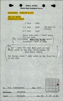
The ISGS field notes mention Lewis Lucking and Ed Lucking in conjunction with this mine. This location may be related to mine index [[7880]]. | |||
{{Production Link}} | {{Production Link}} | ||
| Line 37: | Line 52: | ||
{{Source map header}} | {{Source map header}} | ||
{{Source Map | |||
|Source Map=ISGS field notes (D. M. Collingwood) | |||
|Map Date=1923 | |||
|Original Scale=(text only) | |||
|Digitized Scale=1:24000 {{#info: Point plotted onto 1:24,000 USGS topographic map and digitized.|note}} | |||
|Map Type=Secondary source | |||
}} | |||
{{Annotated bibliography header}} | {{Annotated bibliography header}} | ||
{{Annotated bibliography | {{Annotated bibliography | ||
|bibliography=Directory of Illinois Coal Mines (Macoupin County) - Mine location. | |bibliography=Directory of Illinois Coal Mines (Macoupin County) - Mine location. | ||
}} | |||
{{Annotated bibliography | |||
|bibliography=ISGS field notes (Macoupin County) - Mine type, shaft location, seam, depth, thickness. | |||
}} | }} | ||
==Mine Notes== | ==Mine Notes== | ||
Latest revision as of 15:14, December 13, 2023
Mine Index Number: 4538
| Company Name: | Unknown | ||
|---|---|---|---|
| Mine Name: | Unknown Mine | ||
| Start Date: | Before 1923 | End Date: | Unknown |
| Type of Mine: | Unknown | ||
| Total acres shown: | |||
| Acres after map date: | General Area of mining acres shown: | 18 | |
Shaft, Slope, Drift or Tipple Location(s)
| Type | County | Township-Range | Section | Part Section |
|---|
| Main shaft | Macoupin | 7N 9W | 35 | SE SE NE |
Geology
| Thickness (ft) | |||||
|---|---|---|---|---|---|
| Seam | Depth (ft) | Min | Max | Ave | Mining Method |
| Herrin | 70-80 | 4.0 | 7.0 | 4.5 | Underground |
Geological Problems Reported
Production
| Company | Mine Name | Date | Production (tons) |
Production Notes
The ISGS field notes mention Lewis Lucking and Ed Lucking in conjunction with this mine. This location may be related to mine index 7880.
Coal Report production (if available)
Sources of Data
| Source Map | Map Date | Original Scale | Digitized Scale | Map Type |
| ISGS field notes (D. M. Collingwood) | 1923 | (text only) | 1:24000 Point plotted onto 1:24,000 USGS topographic map and digitized. | Secondary source |
Annotated Bibliography (Data source - brief description of information)
| Directory of Illinois Coal Mines (Macoupin County) - Mine location. |
| ISGS field notes (Macoupin County) - Mine type, shaft location, seam, depth, thickness. |
Mine Notes
Mine Images

Photographs