0801: Difference between revisions
Kate.O'Brien (talk | contribs) No edit summary |
No edit summary |
||
| (6 intermediate revisions by 2 users not shown) | |||
| Line 1: | Line 1: | ||
{{Sidebar Info Query}} | {{Sidebar Info Query}} | ||
{{Header | {{Header | ||
|checked= | |checked=Entry Completed | ||
|unlocated=No | |unlocated=No | ||
|shown_on_map=Yes | |shown_on_map=Yes | ||
| Line 8: | Line 8: | ||
|Mine Name Header=Sahara No. 16 Mine | |Mine Name Header=Sahara No. 16 Mine | ||
|mine_type=Underground | |mine_type=Underground | ||
|mined-out-area=2, | |mined-out-area=2,861 | ||
|indicated=No | |||
|county1=Saline | |county1=Saline | ||
|quad1=Harrisburg | |quad1=Harrisburg | ||
| Line 14: | Line 15: | ||
|quad2=Harco | |quad2=Harco | ||
|quad3=Carrier Mills | |quad3=Carrier Mills | ||
|city1=Harrisburg | |||
|year-start=1913 | |year-start=1913 | ||
|year-end=1971 | |year-end=1971 | ||
|Latitude= | |Latitude=37.73261377 | ||
|Longitude= | |Longitude=-88.6118854 | ||
|Zoom= | |Zoom=13 | ||
}} | }} | ||
==Shaft, Slope, Drift or Tipple Location(s)== | ==Shaft, Slope, Drift or Tipple Location(s)== | ||
| Line 31: | Line 33: | ||
}} | }} | ||
{{Shaft locations | {{Shaft locations | ||
|shaft_type=Air shaft | |shaft_type=Air shaft {{#info:The old shaft was converted to an air shaft in 1941, when the new slope was constructed.|note}} | ||
|County=Saline | |County=Saline | ||
|Town-Range=9S 5E | |Town-Range=9S 5E | ||
| Line 66: | Line 68: | ||
|Date=1913-1920 | |Date=1913-1920 | ||
|Production=41,322 | |Production=41,322 | ||
|Sum=No | |||
}} | }} | ||
{{Production | {{Production | ||
| Line 72: | Line 75: | ||
|Date=1920-1924 | |Date=1920-1924 | ||
|Production=598,492 | |Production=598,492 | ||
|Sum=No | |||
}} | }} | ||
{{Production | {{Production | ||
| Line 78: | Line 82: | ||
|Date=1924-1927 | |Date=1924-1927 | ||
|Production=285,917 | |Production=285,917 | ||
|Sum=No | |||
}} | }} | ||
{{Production | {{Production | ||
| | |company_note=Idle | ||
|Date=1927-1941 | |Date=1927-1941 | ||
|Sum=No | |||
}} | }} | ||
{{Production | {{Production | ||
| Line 88: | Line 94: | ||
|Date=1941-1950 | |Date=1941-1950 | ||
|Production=4,359,557 | |Production=4,359,557 | ||
|Sum=No | |||
}} | }} | ||
{{Production | {{Production | ||
| Line 94: | Line 101: | ||
|Date=1951-1971 | |Date=1951-1971 | ||
|Production=12,115,092 | |Production=12,115,092 | ||
|Sum=No | |||
| | |||
}} | }} | ||
{{Production | {{Production | ||
|Production=17,400,380 | |Production=17,400,380 | ||
|Sum=Yes | |||
}} | }} | ||
===Production Notes=== | ===Production Notes=== | ||
| Line 108: | Line 114: | ||
{{Source map header}} | {{Source map header}} | ||
{{Source Map | {{Source Map | ||
|Source Map= | |Source Map=State archive, IL_356_01 | ||
|Map Date=12-23-1971 | |Map Date=12-23-1971 | ||
|Original Scale=1:2400 | |Original Scale=1:2400 | ||
|Digitized Scale=1: | |Digitized Scale=1:2400 | ||
|Map Type=Final | |Map Type=Final | ||
}} | }} | ||
| Line 125: | Line 131: | ||
}} | }} | ||
{{Annotated bibliography | {{Annotated bibliography | ||
|bibliography= | |bibliography=State archive, IL_356_01 - Slope and shaft locations, mine outline, mining method, geologic problems. | ||
}} | }} | ||
==Mine Notes== | ==Mine Notes== | ||
| Line 136: | Line 142: | ||
{{Photo Query}} | {{Photo Query}} | ||
{{Page Notes}} | |||
{{Editwithform}} | {{Editwithform}} | ||
Latest revision as of 15:37, May 8, 2024
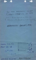
Mine Index Number: 0801
| Company Name: | Sahara Coal Company, Inc. | ||
|---|---|---|---|
| Mine Name: | Sahara No. 16 Mine | ||
| Start Date: | 1913 | End Date: | 1971 |
| Type of Mine: | Underground | ||
| Total acres shown: | 2,861 | ||
| Acres after map date: | General Area of mining acres shown: | ||
Shaft, Slope, Drift or Tipple Location(s)
| Type | County | Township-Range | Section | Part Section |
|---|
| Main slope | Saline | 9S 5E | 13 | SE SW SW |
| Air shaft The old shaft was converted to an air shaft in 1941, when the new slope was constructed. | Saline | 9S 5E | 13 | SW SW SW |
| Escape (old air) shaft | Saline | 9S 5E | 13 | SE SW SW |
Geology
| Thickness (ft) | |||||
|---|---|---|---|---|---|
| Seam | Depth (ft) | Min | Max | Ave | Mining Method |
| Springfield | 189-200 | 5.0 | 7.0 | 6.5 | RPP |
Geological Problems Reported
The mine had many faults, trending northwest-southeast. These faults controlled the mine plan to some extent, specifically in the southeastern part of the mine, where a large block was left unmined. The roof was not good, the seam was “hilly”, and the floor heaved slightly.
Production
| Company | Mine Name | Date | Production (tons) |
| Elder and Bixler Coal Company | Elder and Bixler | 1913-1920 | 41,322 |
| Harrisburg Coal Mining Company | Blue Bird | 1920-1924 | 598,492 |
| Harrisburg Coal Mining Company | Harrisburg No. 1 | 1924-1927 | 285,917 |
| Idle | 1927-1941 | ||
| Bankston Creek Collieries Company | Bankston Creek No. 16 | 1941-1950 | 4,359,557 |
| Sahara Coal Company, Inc. | Sahara No. 16 | 1951-1971 | 12,115,092 |
| Total Production: 17,400,380 | |||
Production Notes
Coal Report production (if available)
Sources of Data
| Source Map | Map Date | Original Scale | Digitized Scale | Map Type |
| State archive, IL_356_01 | 12-23-1971 | 1:2400 | 1:2400 | Final |
Annotated Bibliography (Data source - brief description of information)
| Coal Reports - Production, ownership, years of operation, depth. |
| Directory of Illinois Coal Mines (Saline County) - Mine names, mine index, ownership, years of operation. |
| Mine notes (Saline County) - Mine type, slope location, seam, depth, thickness, geologic problems. |
| State archive, IL_356_01 - Slope and shaft locations, mine outline, mining method, geologic problems. |
Mine Notes
Mine Images
![[[:Sahara No. 16|Sahara No. 16]]](https://wikiimage.isgs.illinois.edu/ilmines/saline/thumbnails/m0801_IL_356_06_th.jpg)
Photographs