Harrisburg Quadrangle
Mining in the Harrisburg Quadrangle
The earliest mining in Saline County was just south of Harrisburg, by John Riben Norman (mine index 4717), who operated a small drift mine from as early as 1856 until the late 1870s. This mine was leased by John Davenport. David Ingram operated a drift mine two miles east of Norman’s just a few years later. No production was reported after 1882 under the name David Ingram, but several Ingram mines operated through the years (see the unlocated mines). The precise location of this early mine is not known, but it may have been in the NW ¼ of Section 26, T9S-R6E, where Ingram Hill Church is still shown on the USGS 7.5-minute topographic map. This area was later surface-mined (see mine index 4267). The first shipping mine opened in 1873, a slope mine about 3 miles southwest of Harrisburg, near Ledford (shown on the accompanying map as mine index 4708, located from an 1876 atlas). W. H. Howell and John Davenport also opened mines near Ledford in 1880 (see the unlocated mines).
Four seams have been mined in this quadrangle, and all have been mined from the surface as well as underground. Most of the mining took place in the Springfield Coal, which crops out just south of Harrisburg. The Springfield Coal generally ranges from 4.5 to 8.0 feet thick and averages about 5 feet thick over the area. The Springfield Coal was not deposited or is split into two or more seams by shale in the area west of Harrisburg. This is near the Galatia Channel, which was contemporaneous with the deposition of the Springfield Coal. The Dykersburg Shale overlies the seam in this area,generally making a good roof.
The Herrin Coal was also mined, especially west of Harrisburg, in the vicinity of the Galatia Channel. The Herrin Coal is not as thick as the Springfield Coal in this area, generally less than 5 feet thick. The Dekoven and Davis Coals were mined in the southern part of the quadrangle. They are thinner than the Springfield Coal, generally ranging from less than 3 to about 4 feet thick. These seams were more commonly surface mined where both seams could be mined, such as in Peabody Coal Company’s Will Scarlet Mine (mine index 697).
The Cottage Grove Fault System runs through the area, and locally interfered with the mining pattern or prevented expansion in some directions. These faults made mining more expensive in some locations, but did not prevent mining of the areas in which they occur.
Map and Directory PDF Download
Coal Mines In Illinois Harrisburg Quadrangle
Mines that Appear on the Harrisburg-Quadrangle Quadrangle
Unlocated Mines
Saline County
Pages in category "Harrisburg Quadrangle"
The following 99 pages are in this category, out of 99 total.
3
4
Media in category "Harrisburg Quadrangle"
The following 57 files are in this category, out of 57 total.
 M-968 OGara CC no 7 Coop 17 Fig 13 7ft coal 80ft deep.jpg 2,500 × 1,457; 622 KB
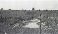
 M-969 Breaks in field S of OGara Co No 7 Harrisburg.jpg 4,376 × 2,548; 1.39 MB
 M0043 minenotes.pdf 731 × 1,172, 27 pages; 5.87 MB
 M0044 minenotes.pdf 731 × 1,172, 27 pages; 5.61 MB
 M0048 minenotes.pdf 731 × 1,172, 20 pages; 3.56 MB
 M0128 minenotes.pdf 731 × 1,172, 12 pages; 8.8 MB
 M0330 minenotes.pdf 731 × 1,172, 11 pages; 2.23 MB
 M0450 minenotes.pdf 731 × 1,172, 17 pages; 3.32 MB
 M0535 minenotes.pdf 731 × 1,172, 13 pages; 2.81 MB
 M0608 minenotes.pdf 731 × 1,172, 3 pages; 415 KB
 M0610 minenotes.pdf 733 × 1,172, 12 pages; 3.97 MB
 M0638 fieldnotes.pdf 745 × 1,191; 232 KB
 M0638 minenotes Cady.pdf 1,245 × 1,635, 2 pages; 16.97 MB
 M0638 minenotes.pdf 737 × 1,172, 88 pages; 11.68 MB
 M0672 minenotes.pdf 718 × 1,160, 4 pages; 721 KB
 M0697 fieldnotes Saline.pdf 750 × 1,200, 3 pages; 619 KB
 M0697 fieldnotes Williamson.pdf 747 × 1,197, 6 pages; 831 KB
 M0697 minenotes Saline.pdf 718 × 1,160, 5 pages; 699 KB
 M0697 minenotes Williamson.pdf 727 × 1,166, 73 pages; 19.23 MB
 M0801 minenotes.pdf 706 × 1,162, 35 pages; 7.9 MB
 M0840 minenotes.pdf 718 × 1,160, 41 pages; 8.27 MB
 M0919 minenotes.pdf 718 × 1,160, 62 pages; 11.43 MB
 M0931 minenotes.pdf 718 × 1,160, 13 pages; 2.08 MB
 M0989 minenotes.pdf 731 × 1,172, 9 pages; 1.43 MB
 M1015 minenotes.pdf 731 × 1,172, 25 pages; 6 MB
 M3257 minenotes.pdf 731 × 1,172, 3 pages; 621 KB
 M3273 minenotes.pdf 731 × 1,168, 6 pages; 3.77 MB
 M3276 minenotes.pdf 731 × 1,172, 3 pages; 619 KB
 M3277 minenotes.pdf 731 × 1,172, 4 pages; 711 KB
 M3278 minenotes.pdf 731 × 1,172, 3 pages; 524 KB
 M3279 minenotes.pdf 731 × 1,172; 103 KB
 M3280 minenotes.pdf 731 × 1,172, 4 pages; 748 KB
 M3281 minenotes.pdf 731 × 1,172, 27 pages; 5.5 MB
 M3282 minenotes.pdf 731 × 1,172, 2 pages; 323 KB
 M3283 minenotes.pdf 731 × 1,172, 4 pages; 804 KB
 M3284 minenotes.pdf 731 × 1,172, 5 pages; 1.02 MB
 M3285 minenotes.pdf 731 × 1,172, 2 pages; 340 KB
 M3286 minenotes.pdf 731 × 1,172, 4 pages; 819 KB
 M3287 minenotes.pdf 731 × 1,172, 3 pages; 570 KB
 M3288 minenotes.pdf 731 × 1,172, 2 pages; 282 KB
 M3289 minenotes.pdf 731 × 1,172, 4 pages; 815 KB
 M3290 minenotes.pdf 731 × 1,172, 3 pages; 508 KB
 M3291 minenotes.pdf 731 × 1,172, 2 pages; 341 KB
 M3292 minenotes.pdf 731 × 1,172, 16 pages; 3.39 MB
 M3293 minenotes.pdf 731 × 1,172, 5 pages; 1.09 MB
 M3294 minenotes.pdf 731 × 1,172, 2 pages; 492 KB
 M3315 minenotes.pdf 733 × 1,172, 2 pages; 333 KB
 M3319 minenotes.pdf 718 × 1,160, 7 pages; 1.16 MB
 M3320 minenotes.pdf 718 × 1,160, 3 pages; 527 KB
 M3321 minenotes.pdf 718 × 1,160, 5 pages; 768 KB
 M3323 minenotes.pdf 718 × 1,160, 3 pages; 492 KB
 M3324 minenotes.pdf 718 × 1,160, 4 pages; 699 KB
 M3325 minenotes.pdf 718 × 1,160, 3 pages; 494 KB
 M3326 minenotes.pdf 718 × 1,160, 3 pages; 497 KB
 M4193 minenotes.pdf 718 × 1,160, 3 pages; 537 KB
 M4203 minenotes.pdf 718 × 1,160, 3 pages; 625 KB
 M4241 minenotes.pdf 731 × 1,172, 3 pages; 591 KB

