Mine Index Number: 0048
| Company Name:
|
Saline Valley Coal Company
|
| Mine Name:
|
Saline Valley No. 1 Mine
|
| Start Date:
|
1903
|
End Date:
|
1928
|
| Type of Mine:
|
Underground
|
| Total acres shown:
|
151
|
| Acres after map date:
|
|
General Area of mining acres shown:
|
|
|
|
Shaft, Slope, Drift or Tipple Location(s)
| Type
|
County
|
Township-Range
|
Section
|
Part Section
|
| Main shaft
|
Saline
|
9S 5E
|
36
|
NW SE SW
|
| Slope
|
Saline
|
9S 5E
|
35
|
SW SE SEThese entrances to the mine were from the later operations. No air shaft for the earlier operations was designated on the source maps. The southernmost extension of the mine was made in 1929, when Bluebird No. 1 Mine (mine index 610) worked underground before changing over to surface-mining the coal between the outcrop and the underground mine.
|
| Escapement shaft
|
Saline
|
10S 5E
|
2
|
NE NE NEThese entrances to the mine were from the later operations. No air shaft for the earlier operations was designated on the source maps. The southernmost extension of the mine was made in 1929, when Bluebird No. 1 Mine (mine index 610) worked underground before changing over to surface-mining the coal between the outcrop and the underground mine.
|
Geology
| Springfield
|
83 (70-125)
|
5.0
|
7.5
|
6.25
|
MRP
|
Geological Problems Reported
Small faults with 2-foot offsets were seen in the mine. The coal contained some pyrite. Mining was halted in the southwest due to dirty gray shale lenses in the coal.
Production
| Company
|
Mine Name
|
Date
|
Production (tons)
|
|
|
|
|
|
| Total Production: 953,713
|
Production Notes
Coal Report production (if available)
Sources of Data
| Microfilm, document 352769
|
7-1-1931
|
1:2400
|
1:4468
|
Secondary
|
| WPA, T9S-R5E
|
circa 1934
|
1:12000
|
1:53900
|
Secondary
|
Annotated Bibliography (Data source - brief description of information)
| Coal Reports - Production, ownership, years of operation, depth.
|
| Directory of Illinois Coal Mines (Saline County) - Mine names, mine index, ownership, years of operation.
|
| Mine notes (Saline County) - Mine type, shaft location, seam, depth, thickness, geologic problems.
|
| Microfilm map, document 352769, reel 03140, frame 291, map of Blue Bird Mine (mine index 610) - Slope and shaft locations, mine outline, mining method.
|
| WPA map, T9S-R5E - Shaft location.
|
Mine Notes
Mine Images
 These files may not be true to scale and are not georgistered. These files may not be true to scale and are not georgistered.
|
Map Type:
|
Microfilm
|
| Map ID:
|
352769 3140, 291
|
| Company:
|
|
| Mine Name:
|
|
| Caption:
|
|
| Map Date:
|
07-01-1931
|
| Map Status:
|
Final
|
| Image Credit:
|
|
| Note:
|
Secondary source map for mine index numbers: 0048 & 7908
|
| More Info:
|
M0048
|
| Full Res Download:These files are true to scale and most are georegistered for gis software. These files may be a very large (>1GB) download!
|
https://go.illinois.edu/ILMImages/saline/m0048.zip
|
Photographs
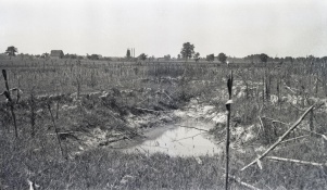
Caption: Surface breaks extending over a room in a mine near Harrisburg where the coal is 7 feet thick and 80 feet deep. The rooms are 24 feet wide and have 24 foot pillars
Credit: Illinois State Geological Survey
Date: Pre-1914
Publication: Fig. 13 Cooperative Bulletin 17 – Subsidence in Illinois
Library No.: M-968
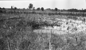
Caption: Breaks in field south of O'Gara No. 7
Credit: Illinois State Geological Survey
Library No.: M-969


