6774: Difference between revisions
Alan.Myers (talk | contribs) m (Text replacement - "Danville Southeast" to "Danville SE") |
Alan.Myers (talk | contribs) No edit summary |
||
| Line 12: | Line 12: | ||
|datemodend=before | |datemodend=before | ||
|year-end=1968 | |year-end=1968 | ||
|Latitude= | |Latitude=40.105267032 | ||
|Longitude= | |Longitude=-87.610359263 | ||
|Zoom= | |Zoom=15 | ||
}} | }} | ||
==Shaft, Slope, Drift or Tipple Location(s)== | ==Shaft, Slope, Drift or Tipple Location(s)== | ||
Revision as of 17:06, November 12, 2020
Mine Index Number: 6774
| Company Name: | |||
|---|---|---|---|
| Mine Name: | |||
| Start Date: | before 1968 | End Date: | before 1968 |
| Type of Mine: | Surface | ||
| Total acres shown: | |||
| Acres after map date: | General Area of mining acres shown: | ||
Shaft, Slope, Drift or Tipple Location(s)
| Type | County | Township-Range | Section | Part Section |
|---|
| Pit (northern) | Vermilion | 19N 11W | 16 | SW |
| Pit (southern) | Vermilion | 19N 11W | 16 | SE |
Geology
| Thickness (ft) | |||||
|---|---|---|---|---|---|
| Seam | Depth (ft) | Min | Max | Ave | Mining Method |
| Herrin | Surface |
Geological Problems Reported
Production
| Company | Mine Name | Date | Production (tons) |
Production Notes
Coal Report production (if available)
Sources of Data
| Source Map | Map Date | Original Scale | Digitized Scale | Map Type |
| USGS topographic map, Danville SE Quadrangle | 1968 | 1:24000 | 1:24000 | Secondary source |
Annotated Bibliography (Data source - brief description of information)
| USGS topographic map, Danville SE (7.5') Quadrangle - Mine outlines. |
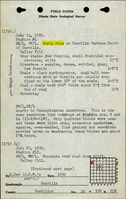
Mine Notes
Mine Images
Photographs