3570: Difference between revisions
No edit summary |
No edit summary |
||
| Line 1: | Line 1: | ||
{{Sidebar Info Query}} | {{Sidebar Info Query}} | ||
{{Header | {{Header | ||
|checked= | |checked=Checked OK | ||
|unlocated=No | |unlocated=No | ||
|shown_on_map=Yes | |shown_on_map=Yes | ||
| Line 10: | Line 10: | ||
|mined-out-area=107 | |mined-out-area=107 | ||
|after_map=12 | |after_map=12 | ||
|indicated=No | |||
|county1=St. Clair | |county1=St. Clair | ||
|quad1=Freeburg | |quad1=Freeburg | ||
|datemod=Pre | |||
|year-start=1874 | |year-start=1874 | ||
|year-end=March 1925 | |year-end=March 1925 | ||
Latest revision as of 11:26, October 6, 2022
Mine Index Number: 3570
| Company Name: | New Freeburg Coal Company | ||
|---|---|---|---|
| Mine Name: | New Freeburg Mine | ||
| Start Date: | Pre 1874 | End Date: | March 1925 |
| Type of Mine: | Underground | ||
| Total acres shown: | 107 | ||
| Acres after map date: | 12 | General Area of mining acres shown: | |
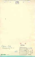
Shaft, Slope, Drift or Tipple Location(s)
| Type | County | Township-Range | Section | Part Section |
|---|
| Main shaft (5.5' x 12') | St. Clair | 1S 7W | 30 | SW SE NE |
| Air shaft | St. Clair | 1S 7W | 30 | SW SE NE |
Geology
| Thickness (ft) | |||||
|---|---|---|---|---|---|
| Seam | Depth (ft) | Min | Max | Ave | Mining Method |
| Herrin | 122 | 6.0-7.0 | MRP RPB in southwestern part of mine |
Geological Problems Reported
Several small faults were encountered in the mine, with offsets of 0.5 to 2 feet. The roof shale contained concretions. The largest of these concretions was 10 inches by 3 inches by 2 inches.
Production
| Company | Mine Name | Date | Production (tons) |
| Freeburg Coal Company | Freeburg | pre1874-1886 | 47,550 Production and ownership prior to 1882 are unknown. The Coal Report of 1882 indicates 17 acres mined. The mine was included in the 1874 Atlas of St. Clair County. Idle 1886. |
| Consolidated Coal Company of St. Louis | Freeburg | 1886-1887 | 9,596 |
| Freeburg Coal Company | Freeburg | 1887-1891 | 43,800 |
| Charles Becker | Freeburg | 1891-1896 | 77,680 |
| Freeburg Mining Company | Freeburg | 1896-1901 | 109,079 |
| Sunlight Coal Company | Becker, Sunlight No. 1 | 1901-1905 | 148,483 |
| Johnson Coal Company | Sunlight | 1905-1909 | 130,922 |
| Sunlight Coal Company | Freeburg | 1909-1913 Idle 1913 | 58,378 |
| Victoria Coal Company | New Freeburg | 1913-1915 | 44,372 |
| New Freeburg Coal Company | Famous | 1915-1917 | 41,434 |
| Columbia Colliery Company | New Freeburg,Famous | 1917-1920 | 82,789 |
| Columbia Colliery Company | New Freeburg,Famous | 1920-1924 Idle 1924 | 61,011 Production after map date |
| New Freeburg Coal Company | New Freeburg | 1924-1925 | 14,583 Production after map date |
| Total Production: 869,677 | |||
Production Notes
Coal Report production (if available)
Sources of Data
| Source Map | Map Date | Original Scale | Digitized Scale | Map Type |
| State archive, IL_178 | 6-26-1920 | 1:1200 | 1:1986 | Not final |
Annotated Bibliography (Data source - brief description of information)
| Coal Reports - Production, ownership, years of operation. |
| Directory of Illinois Coal Mines (St. Clair County) - Mine names, mine index, ownership, years of operation. |
| Mine notes (St. Clair County) - Mine type, seam, depth, thickness, geologic problems. |
| State archive, IL_178 - Shaft locations, outline, mining method. |
| 1874 Atlas of St. Clair County - Years of operation. |
Mine Notes
Mine Images


Photographs