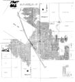
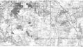
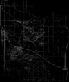
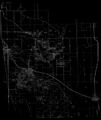
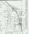
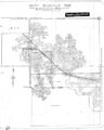
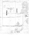
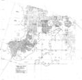
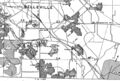
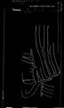
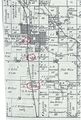
Freeburg Quadrangle
Mining in the Freeburg Quadrangle
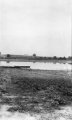
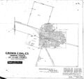
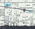
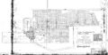
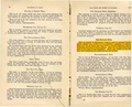
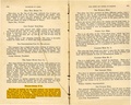
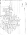
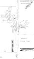
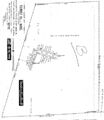
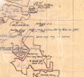
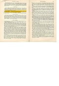
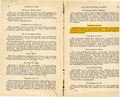
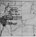
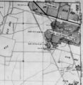
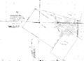
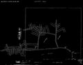
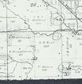
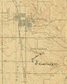
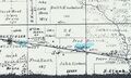
Mining in this quadrangle began prior to 1874, and continued until 1989. The date of the earliest mining is not known; the 1874 Atlas of St. Clair County shows mines in the Belleville and Rentchler areas. The most recent (and largest) mine in the Freeburg quadrangle is the River King Underground Mine (mine index 940), just east of Freeburg. Three of the mines in this area operated for long periods; the Richland Mine (mine index 790) operated for 68 years, the Randle Mine (mine index 3565) operated for 53 years, and the Reinheimer Slope Mine (mine index 789) operated for 51 years.
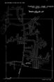
The Herrin Coal was the only coal mined here, ranging from 5.0 to 11.5 feet thick and 8 to 267 feet deep. Several mines reported water, and a number of mines reported problems with the mine floor "heaving" or "squeezing". These problems typically occur in wet conditions such as this where the bedrock cover above the coal is relatively thin.
Map and Directory PDF Download
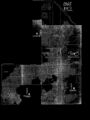
Coal Mines In Illinois Freeburg Quadrangle
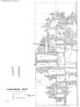
Mines that Appear on the Freeburg Quadrangle
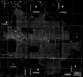
Unlocated Mines
St. Clair County
Pages in category "Freeburg Quadrangle"
The following 100 pages are in this category, out of 100 total.
1
- 1630010
- 1630011
- 1630012
- 1630023
- 1630026
- 1630027
- 1630028
- 1630034
- 1630035
- 1630036
- 1630051
- 1630053
- 1630055
- 1630061
- 1630063
- 1630064
- 1630065
- 1630066
- 1630068
- 1630071
- 1630075
- 1630076
- 1630077
- 1630081
- 1630086
- 1630093
- 1630094
- 1630099
- 1630106
- 1630107
- 1630110
- 1630113
- 1630118
- 1630120
- 1630123
- 1630125
- 1630126
- 1630127
- 1630129
- 1630130
- 1630136
- 1630137
- 1630139
- 1630145
- 1630151
- 1630157
- 1630165
- 1630174
- 1630175
- 1630176
- 1630178
- 1630195
- 1630200
- 1630201
3
Media in category "Freeburg Quadrangle"
The following 92 files are in this category, out of 92 total.
 M-1035 11 Hippert mine on Freeburg rd freshly filled mine water entering through cave.jpg 2,582 × 4,319; 1.09 MB
 M0307 coalreport1906 p313.pdf 1,583 × 1,258; 347 KB
 M0307 minenotes.pdf 737 × 1,183, 17 pages; 3.58 MB
 M0307.jpg 3,108 × 3,390; 1.72 MB
 M0369 351127.jpg 3,084 × 2,912; 935 KB
 M0369 minenotes.pdf 737 × 1,183, 7 pages; 1.46 MB
 M0500 351034.jpg 3,120 × 2,936; 924 KB
 M0500 minenotes.pdf 741 × 1,179, 11 pages; 10.08 MB
 M0653 minenotes.pdf 733 × 1,187, 18 pages; 13.12 MB
 M0653.jpg 3,390 × 1,915; 3.51 MB
 M0780 atlas 1874.jpg 1,040 × 879; 216 KB
 M0780 minenotes.pdf 733 × 1,183, 2 pages; 960 KB
 M0780.jpg 1,777 × 2,715; 423 KB
 M0784 minenotes.pdf 741 × 1,179, 8 pages; 7.6 MB
 M0784 pb168.jpg 2,279 × 2,119; 873 KB
 M0788 351159.jpg 3,390 × 1,757; 1.03 MB
 M0788 minenotes.pdf 737 × 1,183, 7 pages; 2.49 MB
 M0789 351161.jpg 3,390 × 2,130; 487 KB
 M0789 fieldnotes.pdf 745 × 1,181, 2 pages; 377 KB
 M0789 minenotes.pdf 737 × 1,183, 4 pages; 926 KB
 M0790 coalreport1884 p577.pdf 1,577 × 1,275; 310 KB
 M0790 minenotes.pdf 737 × 1,183, 7 pages; 1.5 MB
 M0790.jpg 3,390 × 2,761; 1.58 MB
 M0791 minenotes.pdf 737 × 1,183, 4 pages; 753 KB
 M0791.jpg 2,652 × 2,680; 1.53 MB
 M0796 minenotes.pdf 737 × 1,183, 8 pages; 1.67 MB
 M0796.jpg 3,390 × 1,776; 495 KB
 M0857 fieldnotes.pdf 750 × 1,187, 2 pages; 428 KB
 M0857 minenotes.pdf 737 × 1,183, 101 pages; 40.46 MB
 M0857.jpg 2,834 × 3,390; 1.12 MB
 M0857mas.jpg 2,860 × 3,390; 1.11 MB
 M0940 minenotes.pdf 745 × 1,162, 267 pages; 30.52 MB
 M1630081 coalreport1884 p574.pdf 1,587 × 1,268; 323 KB
 M3489 minenotes.pdf 733 × 1,183, 3 pages; 1.71 MB
 M3489.jpg 2,527 × 3,390; 929 KB
 M3508 35100701.jpg 3,390 × 1,958; 1.16 MB
 M3508 atlas1874.jpg 1,704 × 2,016; 477 KB
 M3508 coalreport1884.pdf 1,577 × 1,275; 305 KB
 M3508 minenotes.pdf 737 × 1,183, 2 pages; 482 KB
 M3508b 35100702.jpg 3,390 × 2,956; 358 KB
 M3538 350983.jpg 2,694 × 3,390; 831 KB
 M3538 coalreport1884.pdf 1,577 × 1,275; 305 KB
 M3538 coalreport1904.pdf 1,647 × 1,229; 415 KB
 M3539 minenotes.pdf 741 × 1,179, 5 pages; 4.33 MB
 M3539.jpg 2,541 × 3,390; 1.66 MB
 M3541 351005.jpg 1,958 × 3,390; 416 KB
 M3541 351033.jpg 2,704 × 3,390; 1.09 MB
 M3541 minenotes.pdf 741 × 1,179, 2 pages; 1.27 MB
 M3561 351047.jpg 2,928 × 3,390; 630 KB
 M3561 minenotes.pdf 737 × 1,183, 6 pages; 1.18 MB
 M3562 minenotes.pdf 737 × 1,183, 5 pages; 967 KB
 M3562 MOA1950 Area27.jpg 1,314 × 1,220; 282 KB
 M3563 350987.jpg 3,390 × 2,263; 1.34 MB
 M3563 minenotes.pdf 737 × 1,183, 5 pages; 903 KB
 M3563 pb408.jpg 3,390 × 2,478; 371 KB
 M3565 351087.jpg 3,390 × 2,433; 1.64 MB
 M3565 minenotes.pdf 737 × 1,183, 7 pages; 1.57 MB
 M3566 minenotes.pdf 737 × 1,183, 5 pages; 1.03 MB
 M3566.jpg 2,550 × 3,390; 962 KB
 M3567 minenotes.pdf 737 × 1,183, 5 pages; 1.22 MB
 M3567.jpg 3,390 × 2,387; 2.41 MB
 M3568 coalreport1909.pdf 1,666 × 1,229; 416 KB
 M3568 minenotes.pdf 737 × 1,183, 17 pages; 8.42 MB
 M3568.jpg 3,390 × 2,401; 556 KB
 M3569 35104501.jpg 2,389 × 3,390; 1,006 KB
 M3569 35104502.jpg 2,838 × 3,390; 1.57 MB
 M3569 minenotes.pdf 737 × 1,183, 4 pages; 812 KB
 M3570 coalreport1884.pdf 1,577 × 1,275; 309 KB
 M3570 IL178.jpg 3,188 × 2,273; 926 KB
 M3570 minenotes.pdf 737 × 1,183, 4 pages; 4.18 MB
 M3571 minenotes.pdf 737 × 1,183, 4 pages; 738 KB
 M3571 wpa1s7w.jpg 2,207 × 2,253; 607 KB
 M3571 wpa1s8w.jpg 738 × 755; 139 KB
 M3573 minenotes.pdf 737 × 1,183, 5 pages; 934 KB
 M3592 351250.jpg 3,390 × 2,487; 494 KB
 M3616 fieldnotes.pdf 747 × 1,191, 6 pages; 7.49 MB
 M3616 minenotes.pdf 737 × 1,183, 8 pages; 1.79 MB
 M4255.jpg 2,922 × 2,304; 391 KB
 M4274.jpg 3,390 × 3,292; 1.68 MB
 M4280 minenotes.pdf 737 × 1,183, 2 pages; 414 KB
 M4280.jpg 3,390 × 3,126; 2.14 MB
 M4297 351022 wpa.jpg 1,735 × 1,173; 585 KB
 M4298 pb168.jpg 392 × 316; 46 KB
 M4298.jpg 3,281 × 2,012; 392 KB
 M4299 atlas1874 1n8w.jpg 1,582 × 1,623; 365 KB
 M4299.jpg 1,706 × 2,853; 303 KB
 M4320 minenotes.pdf 737 × 1,183, 2 pages; 371 KB
 M4321 minenotes.pdf 737 × 1,183, 2 pages; 363 KB
 M4321.jpg 842 × 1,059; 400 KB
 M4335 atlas1874.jpg 1,810 × 2,683; 836 KB
 M4336 351256.jpg 2,498 × 3,390; 519 KB
 M4373.jpg 1,862 × 1,112; 322 KB


