Mine Index Number: 3616
| Company Name:
|
United Electric Coal Company
|
| Mine Name:
|
Red Ray No. 13 Mine
|
| Start Date:
|
1925
|
End Date:
|
March 1949
|
| Type of Mine:
|
Surface
|
| Total acres shown:
|
459
|
| Acres after map date:
|
27
|
General Area of mining acres shown:
|
|
|
|
Shaft, Slope, Drift or Tipple Location(s)
| Type
|
County
|
Township-Range
|
Section
|
Part Section
|
| Pit
|
St. Clair
|
2S 7W
|
5
|
SE SW NW
|
Geology
Geological Problems Reported
Production
| Company
|
Mine Name
|
Date
|
Production (tons)
|
|
|
|
|
|
| Total Production: 4,991,398
|
Production Notes
Coal Report production (if available)
Sources of Data
| ISGS map library, 4103.S31 i5.1-62
|
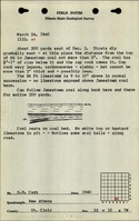
8-1-1947 The Peabody map is dated 3-14-1969, but indicates the survey date of United Electric No. 13 is 1947.
|
1:12000
|
1:12000
|
Secondary source
|
Annotated Bibliography (Data source - brief description of information)
| Coal Reports - Production, ownership, years of operation, thickness, depth, seam.
|
| Directory of Illinois Coal Mines (St. Clair County) - Mine names, mine index, ownership, years of operation.
|
| ISGS map library, 4103.S31. i5.1-62, map of River King Surface Mine (mine index 857) - Mine outline, mining method.
|
Mine Notes
Mine Images
Company: 4103.S31 i5.1-62
Map Date: 3-14-1969
Coal Co.: Peabody Coal Company
Mine Name: River King Surface Mine
Full Res Download
Photographs