Mine Index Number: 0307
| Company Name:
|
Mulberry Hill Coal Company
|
| Mine Name:
|
Mulberry Hill Mine
|
| Start Date:
|
1906
|
End Date:
|
March 1952
|
| Type of Mine:
|
Underground
|
| Total acres shown:
|
633
|
| Acres after map date:
|
|
General Area of mining acres shown:
|
|
|
|
Shaft, Slope, Drift or Tipple Location(s)
| Type
|
County
|
Township-Range
|
Section
|
Part Section
|
| Main shaft (8.5' x 14')
|
St. Clair
|
1S 7W
|
18
|
NW NE SW
|
| Air shaft
|
St. Clair
|
1S 7W
|
18
|
NW NE SW
|
Geology
| Herrin
|
144
|
6.0
|
10.5
|
6.5-6.7
|
MRP
|
Geological Problems Reported
Concretions were common throughout the mine. Roof rolls were common. Horseback-type features were present, with up to one foot of displacement. The source map shows water in the northwestern portion of the mine (1939, 1940).
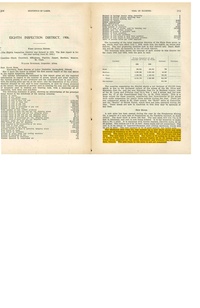
Production
| Company
|
Mine Name
|
Date
|
Production (tons)
|
|
|
|
|
|
| Total Production: 3,877,966
|
Production Notes
Coal Report production (if available)
Sources of Data
| Microfilm, document 351167
|
1-8-1956
|
1:2400
|
1:5297
|
Final
|
Annotated Bibliography (Data source - brief description of information)
| Coal Reports - Production, ownership, years of operation.
|
| Directory of Illinois Coal Mines (St. Clair County) - Mine names, mine index, ownership, years of operation.
|
| Mine notes (St. Clair County) - Mine type, shaft location and size, seam, depth, thickness, geologic problems.
|
| Microfilm map, document 351167, reel 03134, frames 312, 313 - Shaft locations, mine outline, mining method, geologic problems.
|
Mine Notes
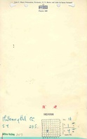
Mine Images
Microfilm: 351167
Map Date: 1-8-1956
Coal Co.: Mulberry Hill Coal Company
Mine Name: Mulberry Hill Mine
Full Res Download
Photographs