Mine Index Number: 0789
| Company Name:
|
Reinheimer
|
| Mine Name:
|
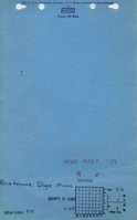
Reinheimer Slope Mine
|
| Start Date:
|
1905
|
End Date:
|
1956
|
| Type of Mine:
|
Underground
|
| Total acres shown:
|
21
|
| Acres after map date:
|
|
General Area of mining acres shown:
|
|
|
Partially stripped by River King Surface Mine (mine index 0857)
|
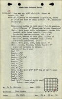
Shaft, Slope, Drift or Tipple Location(s)
| Type
|
County
|
Township-Range
|
Section
|
Part Section
|
| Main slope
|
St. Clair
|
1S 7W
|
32
|
SE SE SE
|
| Air shaft
|
St. Clair
|
1S 7W
|
32
|
SE SE SE not shown on accompanying map due to later surface mining
|
Geology
Geological Problems Reported
Production
| Company
|
Mine Name
|
Date
|
Production (tons)
|
Production Notes
Coal Report production (if available)
Sources of Data
| Microfilm, document 351161
|
1-12-1957
|
1:2400
|
1:2400
|
Final
|
Annotated Bibliography (Data source - brief description of information)
| Coal Reports - Production, ownership, years of operation.
|
| Directory of Illinois Coal Mines (St. Clair County) - Mine names, mine index, ownership, years of operation.
|
| Mine notes (St. Clair County) - Mine type, slope location, seam, thickness.
|
| Microfilm map, document 351161, reel 03134, frame 301 - Slope and shaft locations, mine outline, mining method.
|
Mine Notes
Mine Images
Microfilm: 351161
Map Date: 1-12-1957
Coal Co.: Reinheimer
Mine Name: Reinheimer Slope Mine
Full Res Download
Photographs